Villeréal geodata
Villeréal (Nouvelle-Aquitaine) is a populated place; located in France in Europe/Paris (GMT+2) time zone. With population of 1,285 people, there are 7101 cities with bigger population in this country. Compared to other cities in France, 82.6% of cities are located further ↑North; 71.1% of cities are located further →East and 59.7% of cities have higher elevation than Villeréal. Note1
Administrative division(s):
- Level 1: Nouvelle-Aquitaine
- Level 2: Département du Lot-et-Garonne
- Level 3: Arrondissement de Villeneuve-sur-Lot
- Level 4: Villeréal


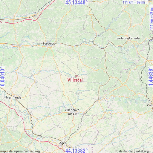
Villeréal GPS coordinates[2]
44° 38' 10.716" North, 0° 44' 35.736" East
| Map corner | latitude | longitude |
|---|---|---|
| Upper-left | 45.13448°, | 0.04013° |
| Center: | 44.63631°, | 0.74326° |
| Lower-right: | 44.13382°, | 1.44638° |
| Map W x H: | 111.3×111.3 km | = 69.2×69.2mi |
| max Lat: | 51.07786° ⇑82.6% North |
| Villeréal: | 44.63631° |
| min Lat: | ⇓17.4% South 41.3874° |
| min Long | Villeréal | max Long |
| -5.08615° | 0.74326° | 9.52242° |
| W 28.9%⇐ | ⇒71.1% E |
Elevation
Elevation of Villeréal is 103 m = 338 ft, and this is 90.7 m = 298 ft below average elevation for this country.
| Max E: |
2333 m = 7654 ft | 59.7% |
| Avg. | 193.7 m = 635 ft | |
| Villeréal | 103 m = 338 ft | |
Min E: |
-1 m = -3 ft | 40.3% |
See also: France elevation on elevation.city.
Geographical zone
Villeréal is located in North temperate zone (between Tropic of Cancer and the Arctic Circle). Distance of this Northern Tropic circle is 2357.2 km =1464.7 mi to South.| Distance of | km | miles | from Villeréal |
|---|---|---|---|
| North Pole | 5044 | 3134.2 | to North |
| Arctic Circle | 2438.1 | 1515 | to North |
| Tropic Cancer | 2357.2 | 1464.7 | to South |
| Equator | 4963.1 | 3083.9 | to South |


Nearby cities:
15 places around Villeréal: (largest is in red/bold)
• Beaumont-du-Périgord
14.6 km =9.1 mi,  8°
8°
• Blanquefort-sur-Briolance
18.2 km =11.3 mi,  103°
103°
• Cancon
14.6 km =9.1 mi,  219°
219°
• Capdrot
15 km =9.3 mi,  70°
70°
• Castelnaud-de-Gratecambe
16.7 km =10.4 mi,  200°
200°
• Castillonnès
12.1 km =7.5 mi,  278°
278°
• Cuzorn
19.3 km =12 mi,  122°
122°
• Issigeac
14.9 km =9.3 mi,  313°
313°
• Lédat
21.2 km =13.2 mi, 195°
• Monbahus
19.2 km =11.9 mi,  239°
239°
• Monflanquin
12 km =7.5 mi,  170°
170°
• Monpazier
13 km =8.1 mi, 67°
• Saint-Eutrope-de-Born
7.6 km =4.7 mi,  212°
212°
• Saint-Front-sur-Lémance
19.4 km =12.1 mi,  110°
110°
• Saint-Hilaire
11.6 km =7.2 mi,  190°
190°
Sources, notices
• [Note1] Compared only with cities in France existing in our database
• [Src1] Map data: © OpenStreetMap contributors (CC-BY-SA)
• [Src2] Other city data from geonames.org with taken over terms of usage.
• [Src3] Geographical zone / Annual Mean Temperature by Robert A. Rohde @ Wikipedia
