Monbahus geodata
Monbahus (Nouvelle-Aquitaine) is a populated place; located in France in Europe/Paris (GMT+2) time zone. With population of 752 people, there are 11147 cities with bigger population in this country. Compared to other cities in France, 83.2% of cities are located further ↑North; 73.1% of cities are located further →East and 56.3% of cities have lower elevation than Monbahus. Note1
Administrative division(s):
- Level 1: Nouvelle-Aquitaine
- Level 2: Département du Lot-et-Garonne
- Level 3: Arrondissement de Villeneuve-sur-Lot
- Level 4: Monbahus


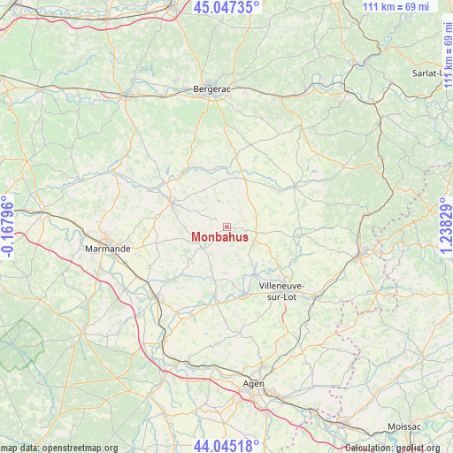
Monbahus GPS coordinates[2]
44° 32' 54.312" North, 0° 32' 6.612" East
| Map corner | latitude | longitude |
|---|---|---|
| Upper-left | 45.04735°, | -0.16796° |
| Center: | 44.54842°, | 0.53517° |
| Lower-right: | 44.04518°, | 1.23829° |
| Map W x H: | 111.4×111.4 km | = 69.2×69.2mi |
| max Lat: | 51.07786° ⇑83.2% North |
| Monbahus: | 44.54842° |
| min Lat: | ⇓16.8% South 41.3874° |
| min Long | Monbahus | max Long |
| -5.08615° | 0.53517° | 9.52242° |
| W 26.9%⇐ | ⇒73.1% E |
Elevation
Elevation of Monbahus is 155 m = 509 ft, and this is 38.7 m = 127 ft below average elevation for this country.
| Max E: |
2333 m = 7654 ft | 43.7% |
| Avg. | 193.7 m = 635 ft | |
| Monbahus | 155 m = 509 ft | |
Min E: |
-1 m = -3 ft | 56.3% |
See also: France elevation on elevation.city.
Geographical zone
Monbahus is located in North temperate zone (between Tropic of Cancer and the Arctic Circle). Distance of this Northern Tropic circle is 2347.4 km =1458.6 mi to South.| Distance of | km | miles | from Monbahus |
|---|---|---|---|
| North Pole | 5053.7 | 3140.2 | to North |
| Arctic Circle | 2447.9 | 1521.1 | to North |
| Tropic Cancer | 2347.4 | 1458.6 | to South |
| Equator | 4953.3 | 3077.8 | to South |


Nearby cities:
15 places around Monbahus: (largest is in red/bold)
• Cancon
7.3 km =4.5 mi,  101°
101°
• Casseneuil
13.5 km =8.4 mi,  149°
149°
• Castelnaud-de-Gratecambe
12 km =7.5 mi,  118°
118°
• Castillonnès
12.4 km =7.7 mi,  21°
21°
• Fongrave
10.8 km =6.7 mi,  261°
261°
• Lauzun
10.8 km =6.7 mi,  327°
327°
• Lavergne
11.9 km =7.4 mi,  293°
293°
• Lédat
15.1 km =9.4 mi,  134°
134°
• Miramont-de-Guyenne
14.9 km =9.3 mi, 293°
• Monclar
10.9 km =6.8 mi,  180°
180°
• Pinel-Hauterive
13.7 km =8.5 mi,  164°
164°
• Saint-Eutrope-de-Born
12.8 km =8 mi,  74°
74°
• Saint-Hilaire
14.5 km =9 mi, 96°
• Saint-Pardoux-Isaac
14.6 km =9.1 mi,  298°
298°
• Saint-Étienne-de-Fougères
14.5 km =9 mi,  173°
173°
Sources, notices
• [Note1] Compared only with cities in France existing in our database
• [Src1] Map data: © OpenStreetMap contributors (CC-BY-SA)
• [Src2] Other city data from geonames.org with taken over terms of usage.
• [Src3] Geographical zone / Annual Mean Temperature by Robert A. Rohde @ Wikipedia
