Castelnaud-de-Gratecambe geodata
Castelnaud-de-Gratecambe (Nouvelle-Aquitaine) is a populated place; located in France in Europe/Paris (GMT+2) time zone. With population of 546 people, there are 14284 cities with bigger population in this country. Compared to other cities in France, 83.6% of cities are located further ↑North; 71.7% of cities are located further →East and 69% of cities have lower elevation than Castelnaud-de-Gratecambe. Note1
Administrative division(s):
- Level 1: Nouvelle-Aquitaine
- Level 2: Département du Lot-et-Garonne
- Level 3: Arrondissement de Villeneuve-sur-Lot
- Level 4: Castelnaud-de-Gratecambe
Current local time in Castelnaud-de-Gratecambe:
05:23 PM, SaturdayDifference from your time zone: hours


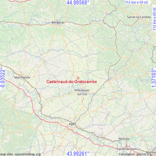
Castelnaud-de-Gratecambe GPS coordinates[2]
44° 29' 46.68" North, 0° 40' 4.44" East
| Map corner | latitude | longitude |
|---|---|---|
| Upper-left | 44.99568°, | -0.03522° |
| Center: | 44.4963°, | 0.6679° |
| Lower-right: | 43.99261°, | 1.37103° |
| Map W x H: | 111.5×111.5 km | = 69.3×69.3mi |
| max Lat: | 51.07786° ⇑83.6% North |
| Castelnaud-de-Gratecambe: | 44.4963° |
| min Lat: | ⇓16.4% South 41.3874° |
| min Long | Castelnaud-de-G | max Long |
| -5.08615° | 0.6679° | 9.52242° |
| W 28.3%⇐ | ⇒71.7% E |
Elevation
Elevation of Castelnaud-de-Gratecambe is 214 m = 702 ft, and this is 20.3 m = 67 ft above average elevation for this country.
| Max E: |
2333 m = 7654 ft | 31% |
| Castelnaud-de-Gratecambe | 214 m 702 ft | |
| Avg. | 193.7 m = 635 ft | |
Min E: |
-1 m = -3 ft | 69% |
See also: France elevation on elevation.city.
Geographical zone
Castelnaud-de-Gratecambe is located in North temperate zone (between Tropic of Cancer and the Arctic Circle). Distance of this Northern Tropic circle is 2341.6 km =1455 mi to South.| Distance of | km | miles | from Castelnaud-de-Gratecambe |
|---|---|---|---|
| North Pole | 5059.5 | 3143.8 | to North |
| Arctic Circle | 2453.6 | 1524.6 | to North |
| Tropic Cancer | 2341.6 | 1455 | to South |
| Equator | 4947.5 | 3074.2 | to South |


Nearby cities:
15 places around Castelnaud-de-Gratecambe: (largest is in red/bold)
• Allez-et-Cazeneuve
11.5 km =7.1 mi,  200°
200°
• Bias
8.9 km =5.5 mi,  179°
179°
• Cancon
5.5 km =3.4 mi,  322°
322°
• Casseneuil
7 km =4.3 mi,  212°
212°
• Lédat
4.8 km =3 mi, 178°
• Monbahus
12 km =7.5 mi,  298°
298°
• Monclar
11.9 km =7.4 mi,  244°
244°
• Monflanquin
8.7 km =5.4 mi,  64°
64°
• Pinel-Hauterive
10.1 km =6.3 mi,  222°
222°
• Pujols
11.5 km =7.1 mi,  171°
171°
• Saint-Eutrope-de-Born
9.3 km =5.8 mi,  11°
11°
• Saint-Hilaire
5.6 km =3.5 mi,  43°
43°
• Saint-Étienne-de-Fougères
12.4 km =7.7 mi,  226°
226°
• Sainte-Livrade-sur-Lot
12.4 km =7.7 mi, 209°
• Villeneuve-sur-Lot
10.2 km =6.3 mi,  163°
163°
Sources, notices
• [Note1] Compared only with cities in France existing in our database
• [Src1] Map data: © OpenStreetMap contributors (CC-BY-SA)
• [Src2] Other city data from geonames.org with taken over terms of usage.
• [Src3] Geographical zone / Annual Mean Temperature by Robert A. Rohde @ Wikipedia
