Castillonnès geodata
Castillonnès (Nouvelle-Aquitaine) is a populated place; located in France in Europe/Paris (GMT+2) time zone. With population of 1,526 people, there are 6101 cities with bigger population in this country. Compared to other cities in France, 82.4% of cities are located further ↑North; 72.4% of cities are located further →East and 50.5% of cities have higher elevation than Castillonnès. Note1
Administrative division(s):
- Level 1: Nouvelle-Aquitaine
- Level 2: Département du Lot-et-Garonne
- Level 3: Arrondissement de Villeneuve-sur-Lot
- Level 4: Castillonnès


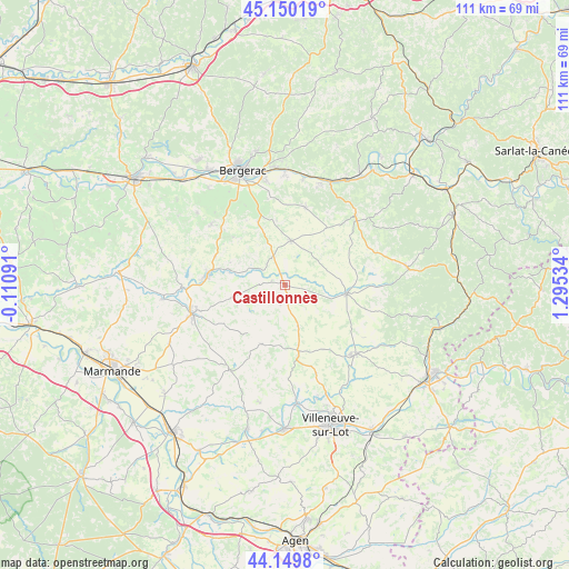
Castillonnès GPS coordinates[2]
44° 39' 7.74" North, 0° 35' 31.992" East
| Map corner | latitude | longitude |
|---|---|---|
| Upper-left | 45.15019°, | -0.11091° |
| Center: | 44.65215°, | 0.59222° |
| Lower-right: | 44.1498°, | 1.29534° |
| Map W x H: | 111.2×111.2 km | = 69.1×69.1mi |
| max Lat: | 51.07786° ⇑82.4% North |
| Castillonnès: | 44.65215° |
| min Lat: | ⇓17.6% South 41.3874° |
| min Long | Castillonnès | max Long |
| -5.08615° | 0.59222° | 9.52242° |
| W 27.6%⇐ | ⇒72.4% E |
Elevation
Elevation of Castillonnès is 130 m = 427 ft, and this is 63.7 m = 209 ft below average elevation for this country.
| Max E: |
2333 m = 7654 ft | 50.5% |
| Avg. | 193.7 m = 635 ft | |
| Castillonnès | 130 m = 427 ft | |
Min E: |
-1 m = -3 ft | 49.5% |
See also: France elevation on elevation.city.
Geographical zone
Castillonnès is located in North temperate zone (between Tropic of Cancer and the Arctic Circle). Distance of this Northern Tropic circle is 2358.9 km =1465.8 mi to South.| Distance of | km | miles | from Castillonnès |
|---|---|---|---|
| North Pole | 5042.2 | 3133.1 | to North |
| Arctic Circle | 2436.3 | 1513.8 | to North |
| Tropic Cancer | 2358.9 | 1465.8 | to South |
| Equator | 4964.9 | 3085 | to South |


Nearby cities:
15 places around Castillonnès: (largest is in red/bold)
• Bouniagues
12.9 km =8 mi,  336°
336°
• Cancon
13.2 km =8.2 mi,  168°
168°
• Castelnaud-de-Gratecambe
18.3 km =11.4 mi,  160°
160°
• Eymet
15.3 km =9.5 mi,  276°
276°
• Issigeac
8.7 km =5.4 mi,  7°
7°
• Lauzun
10.6 km =6.6 mi,  256°
256°
• Lavergne
16.8 km =10.4 mi,  246°
246°
• Monbahus
12.4 km =7.7 mi,  201°
201°
• Monbazillac
17.6 km =10.9 mi,  333°
333°
• Saint-Eutrope-de-Born
11.3 km =7 mi,  136°
136°
• Saint-Hilaire
16.5 km =10.3 mi, 143°
• Saint-Nexans
17.1 km =10.6 mi,  348°
348°
• Saint-Pardoux-Isaac
17.9 km =11.1 mi, 255°
• Sigoulès
18.6 km =11.6 mi,  309°
309°
• Villeréal
12.1 km =7.5 mi,  98°
98°
Sources, notices
• [Note1] Compared only with cities in France existing in our database
• [Src1] Map data: © OpenStreetMap contributors (CC-BY-SA)
• [Src2] Other city data from geonames.org with taken over terms of usage.
• [Src3] Geographical zone / Annual Mean Temperature by Robert A. Rohde @ Wikipedia
