Villedieu-les-Poêles geodata
Villedieu-les-Poêles (Normandy) is a populated place; located in France in Europe/Paris (GMT+2) time zone. With population of 3,927 people, there are 2507 cities with bigger population in this country. Compared to other cities in France, 76.2% of cities are located further ↓South; 90.1% of cities are located further →East and 52.3% of cities have higher elevation than Villedieu-les-Poêles. Note1
Administrative division(s):
- Level 1: Normandy
- Level 2: Manche
- Level 3: Arrondissement de Saint-Lô
- Level 4: Villedieu-les-Poêles-Rouffigny


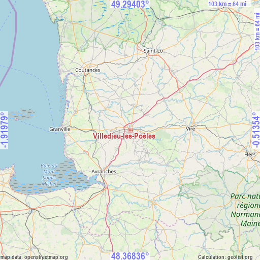
Villedieu-les-Poêles GPS coordinates[2]
48° 49' 59.988" North, 1° 13' 0.012" West
| Map corner | latitude | longitude |
|---|---|---|
| Upper-left | 49.29403°, | -1.91979° |
| Center: | 48.83333°, | -1.21667° |
| Lower-right: | 48.36836°, | -0.51354° |
| Map W x H: | 102.9×102.9 km | = 63.9×63.9mi |
| max Lat: | 51.07786° ⇑23.8% North |
| Villedieu-les-Poêles: | 48.83333° |
| min Lat: | ⇓76.2% South 41.3874° |
| min Long | Villedieu-les-P | max Long |
| -5.08615° | -1.21667° | 9.52242° |
| W 9.9%⇐ | ⇒90.1% E |
Elevation
Elevation of Villedieu-les-Poêles is 124 m = 407 ft, and this is 69.7 m = 229 ft below average elevation for this country.
| Max E: |
2333 m = 7654 ft | 52.3% |
| Avg. | 193.7 m = 635 ft | |
| Villedieu-les-Poêles | 124 m = 407 ft | |
Min E: |
-1 m = -3 ft | 47.7% |
See also: France elevation on elevation.city.
Geographical zone
Villedieu-les-Poêles is located in North temperate zone (between Tropic of Cancer and the Arctic Circle). Distance of this North polar circle is 1971.4 km =1225 mi to North.| Distance of | km | miles | from Villedieu-les-Poêles |
|---|---|---|---|
| North Pole | 4577.3 | 2844.2 | to North |
| Arctic Circle | 1971.4 | 1225 | to North |
| Tropic Cancer | 2823.8 | 1754.6 | to South |
| Equator | 5429.8 | 3373.9 | to South |


Nearby cities:
15 places around Villedieu-les-Poêles: (largest is in red/bold)
• Beslon
5.1 km =3.2 mi,  69°
69°
• Brécey
12.7 km =7.9 mi,  163°
163°
• Coulouvray-Boisbenâtre
9.4 km =5.8 mi,  123°
123°
• Courson
10.4 km =6.5 mi,  76°
76°
• Fleury
4.6 km =2.9 mi,  289°
289°
• Folligny
14.3 km =8.9 mi,  266°
266°
• Gavray
13.1 km =8.1 mi,  311°
311°
• Hambye
13.2 km =8.2 mi,  344°
344°
• La Colombe
5.4 km =3.4 mi,  29°
29°
• La Haye-Pesnel
13.8 km =8.6 mi,  252°
252°
• Percy
9.5 km =5.9 mi,  12°
12°
• Saint-Pois
14.4 km =8.9 mi,  130°
130°
• Saint-Sever-Calvados
12.4 km =7.7 mi,  86°
86°
• Sainte-Cécile
2 km =1.2 mi, 84°
• Tirepied
14.2 km =8.8 mi,  194°
194°
Sources, notices
• [Note1] Compared only with cities in France existing in our database
• [Src1] Map data: © OpenStreetMap contributors (CC-BY-SA)
• [Src2] Other city data from geonames.org with taken over terms of usage.
• [Src3] Geographical zone / Annual Mean Temperature by Robert A. Rohde @ Wikipedia
