Coulouvray-Boisbenâtre geodata
Coulouvray-Boisbenâtre (Normandy) is a populated place; located in France in Europe/Paris (GMT+2) time zone. With population of 543 people, there are 14333 cities with bigger population in this country. Compared to other cities in France, 75.3% of cities are located further ↓South; 89.2% of cities are located further →East and 78.5% of cities have lower elevation than Coulouvray-Boisbenâtre. Note1
Administrative division(s):
- Level 1: Normandy
- Level 2: Manche
- Level 3: Avranches
- Level 4: Coulouvray-Boisbenâtre
Current local time in Coulouvray-Boisbenâtre:
06:28 PM, SaturdayDifference from your time zone: hours


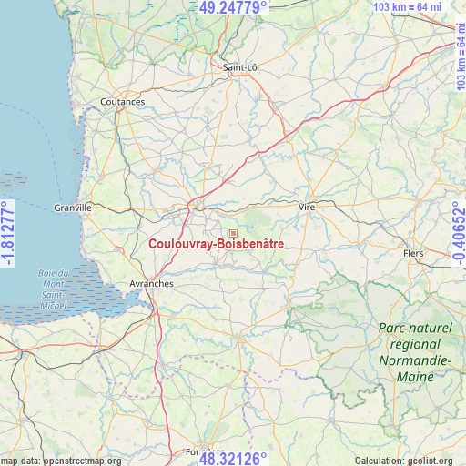
Coulouvray-Boisbenâtre GPS coordinates[2]
48° 47' 11.976" North, 1° 6' 34.704" West
| Map corner | latitude | longitude |
|---|---|---|
| Upper-left | 49.24779°, | -1.81277° |
| Center: | 48.78666°, | -1.10964° |
| Lower-right: | 48.32126°, | -0.40652° |
| Map W x H: | 103×103 km | = 64×64mi |
| max Lat: | 51.07786° ⇑24.7% North |
| Coulouvray-Boisbenâtre: | 48.78666° |
| min Lat: | ⇓75.3% South 41.3874° |
| min Long | Coulouvray-Bois | max Long |
| -5.08615° | -1.10964° | 9.52242° |
| W 10.8%⇐ | ⇒89.2% E |
Elevation
Elevation of Coulouvray-Boisbenâtre is 276 m = 906 ft, and this is 82.3 m = 270 ft above average elevation for this country.
| Max E: |
2333 m = 7654 ft | 21.5% |
| Coulouvray-Boisbenâtre | 276 m 906 ft | |
| Avg. | 193.7 m = 635 ft | |
Min E: |
-1 m = -3 ft | 78.5% |
See also: France elevation on elevation.city.
Geographical zone
Coulouvray-Boisbenâtre is located in North temperate zone (between Tropic of Cancer and the Arctic Circle). Distance of this North polar circle is 1976.6 km =1228.2 mi to North.| Distance of | km | miles | from Coulouvray-Boisbenâtre |
|---|---|---|---|
| North Pole | 4582.5 | 2847.4 | to North |
| Arctic Circle | 1976.6 | 1228.2 | to North |
| Tropic Cancer | 2818.6 | 1751.4 | to South |
| Equator | 5424.6 | 3370.7 | to South |


Nearby cities:
15 places around Coulouvray-Boisbenâtre: (largest is in red/bold)
• Beslon
7.6 km =4.7 mi,  336°
336°
• Brécey
8.1 km =5 mi,  210°
210°
• Courson
7.9 km =4.9 mi,  16°
16°
• Fleury
13.9 km =8.6 mi,  299°
299°
• Juvigny-le-Tertre
13.8 km =8.6 mi,  152°
152°
• La Colombe
11.2 km =7 mi,  332°
332°
• Landelles-et-Coupigny
13.9 km =8.6 mi,  36°
36°
• Le Grand-Celland
13 km =8.1 mi, 205°
• Mesnil-Clinchamps
11.5 km =7.1 mi,  50°
50°
• Reffuveille
13.1 km =8.1 mi,  181°
181°
• Saint-Manvieu-Bocage
10.6 km =6.6 mi,  65°
65°
• Saint-Pois
5.2 km =3.2 mi,  142°
142°
• Saint-Sever-Calvados
7.5 km =4.7 mi, 37°
• Sainte-Cécile
8 km =5 mi,  312°
312°
• Villedieu-les-Poêles
9.4 km =5.8 mi, 303°
Sources, notices
• [Note1] Compared only with cities in France existing in our database
• [Src1] Map data: © OpenStreetMap contributors (CC-BY-SA)
• [Src2] Other city data from geonames.org with taken over terms of usage.
• [Src3] Geographical zone / Annual Mean Temperature by Robert A. Rohde @ Wikipedia
