Brécey geodata
Brécey (Normandy) is a populated place; located in France in Europe/Paris (GMT+2) time zone. With population of 2,336 people, there are 4129 cities with bigger population in this country. Compared to other cities in France, 73.8% of cities are located further ↓South; 89.7% of cities are located further →East and 74.6% of cities have higher elevation than Brécey. Note1


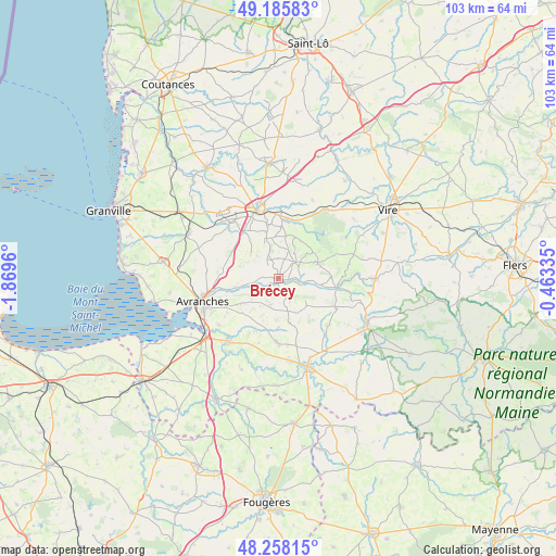
Brécey GPS coordinates[2]
48° 43' 26.868" North, 1° 9' 59.292" West
| Map corner | latitude | longitude |
|---|---|---|
| Upper-left | 49.18583°, | -1.8696° |
| Center: | 48.72413°, | -1.16647° |
| Lower-right: | 48.25815°, | -0.46335° |
| Map W x H: | 103.1×103.1 km | = 64.1×64.1mi |
| max Lat: | 51.07786° ⇑26.2% North |
| Brécey: | 48.72413° |
| min Lat: | ⇓73.8% South 41.3874° |
| min Long | Brécey | max Long |
| -5.08615° | -1.16647° | 9.52242° |
| W 10.3%⇐ | ⇒89.7% E |
Elevation
Elevation of Brécey is 68 m = 223 ft, and this is 125.7 m = 412 ft below average elevation for this country.
| Max E: |
2333 m = 7654 ft | 74.6% |
| Avg. | 193.7 m = 635 ft | |
| Brécey | 68 m = 223 ft | |
Min E: |
-1 m = -3 ft | 25.4% |
See also: France elevation on elevation.city.
Geographical zone
Brécey is located in North temperate zone (between Tropic of Cancer and the Arctic Circle). Distance of this North polar circle is 1983.6 km =1232.6 mi to North.| Distance of | km | miles | from Brécey |
|---|---|---|---|
| North Pole | 4589.4 | 2851.7 | to North |
| Arctic Circle | 1983.6 | 1232.6 | to North |
| Tropic Cancer | 2811.7 | 1747.1 | to South |
| Equator | 5417.6 | 3366.3 | to South |


Nearby cities:
15 places around Brécey: (largest is in red/bold)
• Avranches
14.7 km =9.1 mi,  252°
252°
• Beslon
13.9 km =8.6 mi,  4°
4°
• Coulouvray-Boisbenâtre
8.1 km =5 mi,  30°
30°
• Isigny-le-Buat
11.9 km =7.4 mi,  181°
181°
• Juvigny-le-Tertre
11.8 km =7.3 mi,  116°
116°
• Le Grand-Celland
5 km =3.1 mi,  195°
195°
• Reffuveille
7.3 km =4.5 mi,  147°
147°
• Saint-Loup
11.4 km =7.1 mi,  236°
236°
• Saint-Martin-des-Champs
13.8 km =8.6 mi, 243°
• Saint-Pois
7.9 km =4.9 mi,  68°
68°
• Saint-Quentin-sur-le-Homme
14 km =8.7 mi,  232°
232°
• Saint-Senier-sous-Avranches
12.9 km =8 mi, 249°
• Sainte-Cécile
12.4 km =7.7 mi,  352°
352°
• Tirepied
7.3 km =4.5 mi,  257°
257°
• Villedieu-les-Poêles
12.7 km =7.9 mi,  343°
343°
Sources, notices
• [Note1] Compared only with cities in France existing in our database
• [Src1] Map data: © OpenStreetMap contributors (CC-BY-SA)
• [Src2] Other city data from geonames.org with taken over terms of usage.
• [Src3] Geographical zone / Annual Mean Temperature by Robert A. Rohde @ Wikipedia
