Ville geodata
Ville (Hauts-de-France) is a populated place; located in France in Europe/Paris (GMT+2) time zone. With population of 705 people, there are 11731 cities with bigger population in this country. Compared to other cities in France, 90% of cities are located further ↓South; 56.9% of cities are located further ←West and 75.8% of cities have higher elevation than Ville. Note1
Administrative division(s):
- Level 1: Hauts-de-France
- Level 2: Département de l'Oise
- Level 3: Arrondissement de Compiègne
- Level 4: Ville


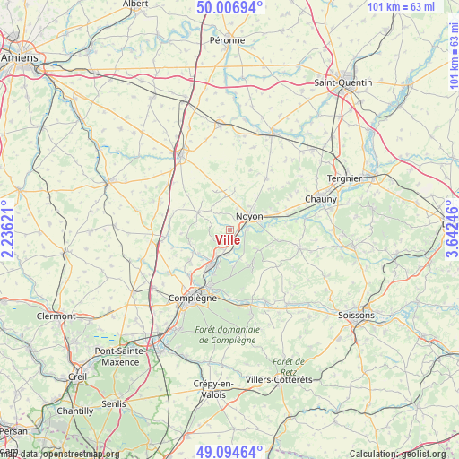
Ville GPS coordinates[2]
49° 33' 10.512" North, 2° 56' 21.624" East
| Map corner | latitude | longitude |
|---|---|---|
| Upper-left | 50.00694°, | 2.23621° |
| Center: | 49.55292°, | 2.93934° |
| Lower-right: | 49.09464°, | 3.64246° |
| Map W x H: | 101.4×101.4 km | = 63×63mi |
| max Lat: | 51.07786° ⇑10% North |
| Ville: | 49.55292° |
| min Lat: | ⇓90% South 41.3874° |
| min Long | Ville | max Long |
| -5.08615° | 2.93934° | 9.52242° |
| W 56.9%⇐ | ⇒43.1% E |
Elevation
Elevation of Ville is 65 m = 213 ft, and this is 128.7 m = 422 ft below average elevation for this country.
| Max E: |
2333 m = 7654 ft | 75.8% |
| Avg. | 193.7 m = 635 ft | |
| Ville | 65 m = 213 ft | |
Min E: |
-1 m = -3 ft | 24.2% |
See also: France elevation on elevation.city.
Geographical zone
Ville is located in North temperate zone (between Tropic of Cancer and the Arctic Circle). Distance of this North polar circle is 1891.4 km =1175.3 mi to North.| Distance of | km | miles | from Ville |
|---|---|---|---|
| North Pole | 4497.3 | 2794.5 | to North |
| Arctic Circle | 1891.4 | 1175.3 | to North |
| Tropic Cancer | 2903.8 | 1804.3 | to South |
| Equator | 5509.8 | 3423.6 | to South |


Nearby cities:
15 places around Ville: (largest is in red/bold)
• Bailly
6.7 km =4.2 mi,  160°
160°
• Cambronne-lès-Ribécourt
5.9 km =3.7 mi,  210°
210°
• Cannectancourt
2.7 km =1.7 mi,  279°
279°
• Carlepont
7.4 km =4.6 mi,  125°
125°
• Chiry-Ourscamp
1.2 km =0.7 mi,  150°
150°
• Dreslincourt
2.9 km =1.8 mi,  197°
197°
• Genvry
7.5 km =4.7 mi,  29°
29°
• Machemont
8 km =5 mi,  219°
219°
• Morlincourt
7.2 km =4.5 mi,  74°
74°
• Noyon
5.5 km =3.4 mi,  52°
52°
• Pimprez
4.3 km =2.7 mi,  167°
167°
• Saint-Léger-aux-Bois
7.8 km =4.8 mi, 171°
• Sempigny
4 km =2.5 mi,  80°
80°
• Suzoy
3.3 km =2.1 mi,  8°
8°
• Thiescourt
4.3 km =2.7 mi,  290°
290°
Sources, notices
• [Note1] Compared only with cities in France existing in our database
• [Src1] Map data: © OpenStreetMap contributors (CC-BY-SA)
• [Src2] Other city data from geonames.org with taken over terms of usage.
• [Src3] Geographical zone / Annual Mean Temperature by Robert A. Rohde @ Wikipedia
