Noyon geodata
Noyon (Hauts-de-France) is a populated place; located in France in Europe/Paris (GMT+2) time zone. With population of 15,138 people, there are 637 cities with bigger population in this country. Compared to other cities in France, 90.4% of cities are located further ↓South; 57.8% of cities are located further ←West and 81.1% of cities have higher elevation than Noyon. Note1
Administrative division(s):
- Level 1: Hauts-de-France
- Level 2: Département de l'Oise
- Level 3: Arrondissement de Compiègne
- Level 4: Noyon


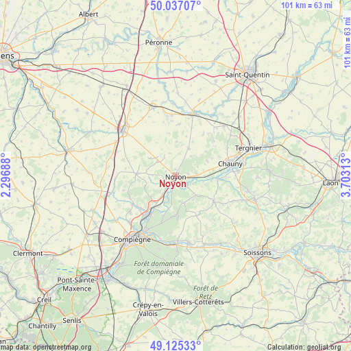
Noyon GPS coordinates[2]
49° 34' 59.988" North, 3° 0' 0" East
| Map corner | latitude | longitude |
|---|---|---|
| Upper-left | 50.03707°, | 2.29688° |
| Center: | 49.58333°, | 3° |
| Lower-right: | 49.12533°, | 3.70313° |
| Map W x H: | 101.4×101.4 km | = 63×63mi |
| max Lat: | 51.07786° ⇑9.6% North |
| Noyon: | 49.58333° |
| min Lat: | ⇓90.4% South 41.3874° |
| min Long | Noyon | max Long |
| -5.08615° | 3° | 9.52242° |
| W 57.8%⇐ | ⇒42.2% E |
Elevation
Elevation of Noyon is 52 m = 171 ft, and this is 141.7 m = 465 ft below average elevation for this country.
| Max E: |
2333 m = 7654 ft | 81.1% |
| Avg. | 193.7 m = 635 ft | |
| Noyon | 52 m = 171 ft | |
Min E: |
-1 m = -3 ft | 18.9% |
See also: France elevation on elevation.city.
Geographical zone
Noyon is located in North temperate zone (between Tropic of Cancer and the Arctic Circle). Distance of this North polar circle is 1888 km =1173.1 mi to North.| Distance of | km | miles | from Noyon |
|---|---|---|---|
| North Pole | 4493.9 | 2792.4 | to North |
| Arctic Circle | 1888 | 1173.1 | to North |
| Tropic Cancer | 2907.2 | 1806.4 | to South |
| Equator | 5513.1 | 3425.7 | to South |


Nearby cities:
15 places around Noyon: (largest is in red/bold)
• Appilly
8.4 km =5.2 mi,  90°
90°
• Cannectancourt
7.6 km =4.7 mi,  247°
247°
• Carlepont
7.8 km =4.8 mi,  167°
167°
• Chiry-Ourscamp
5.8 km =3.6 mi,  220°
220°
• Crisolles
4.5 km =2.8 mi,  13°
13°
• Dreslincourt
8.1 km =5 mi, 220°
• Genvry
3.2 km =2 mi,  348°
348°
• Morlincourt
3 km =1.9 mi,  119°
119°
• Muirancourt
6.8 km =4.2 mi, 6°
• Pimprez
8.4 km =5.2 mi,  204°
204°
• Salency
3.5 km =2.2 mi,  80°
80°
• Sempigny
2.8 km =1.7 mi,  188°
188°
• Suzoy
3.9 km =2.4 mi,  268°
268°
• Thiescourt
8.6 km =5.3 mi,  257°
257°
• Ville
5.5 km =3.4 mi,  232°
232°
Sources, notices
• [Note1] Compared only with cities in France existing in our database
• [Src1] Map data: © OpenStreetMap contributors (CC-BY-SA)
• [Src2] Other city data from geonames.org with taken over terms of usage.
• [Src3] Geographical zone / Annual Mean Temperature by Robert A. Rohde @ Wikipedia
