Vibeuf geodata
Vibeuf (Normandy) is a populated place; located in France in Europe/Paris (GMT+2) time zone. With population of 544 people, there are 14318 cities with bigger population in this country. Compared to other cities in France, 91.5% of cities are located further ↓South; 69.7% of cities are located further →East and 58% of cities have lower elevation than Vibeuf. Note1
Administrative division(s):
- Level 1: Normandy
- Level 2: Seine-Maritime
- Level 3: Arrondissement de Rouen
- Level 4: Vibeuf


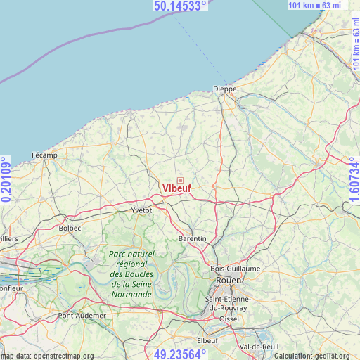
Vibeuf GPS coordinates[2]
49° 41' 33.396" North, 0° 54' 15.156" East
| Map corner | latitude | longitude |
|---|---|---|
| Upper-left | 50.14533°, | 0.20109° |
| Center: | 49.69261°, | 0.90421° |
| Lower-right: | 49.23564°, | 1.60734° |
| Map W x H: | 101.1×101.1 km | = 62.8×62.8mi |
| max Lat: | 51.07786° ⇑8.5% North |
| Vibeuf: | 49.69261° |
| min Lat: | ⇓91.5% South 41.3874° |
| min Long | Vibeuf | max Long |
| -5.08615° | 0.90421° | 9.52242° |
| W 30.3%⇐ | ⇒69.7% E |
Elevation
Elevation of Vibeuf is 161 m = 528 ft, and this is 32.7 m = 107 ft below average elevation for this country.
| Max E: |
2333 m = 7654 ft | 42% |
| Avg. | 193.7 m = 635 ft | |
| Vibeuf | 161 m = 528 ft | |
Min E: |
-1 m = -3 ft | 58% |
See also: France elevation on elevation.city.
Geographical zone
Vibeuf is located in North temperate zone (between Tropic of Cancer and the Arctic Circle). Distance of this North polar circle is 1875.9 km =1165.6 mi to North.| Distance of | km | miles | from Vibeuf |
|---|---|---|---|
| North Pole | 4481.8 | 2784.9 | to North |
| Arctic Circle | 1875.9 | 1165.6 | to North |
| Tropic Cancer | 2919.4 | 1814 | to South |
| Equator | 5525.3 | 3433.3 | to South |


Nearby cities:
15 places around Vibeuf: (largest is in red/bold)
• Biville-la-Baignarde
10.9 km =6.8 mi,  72°
72°
• Criquetot-sur-Ouville
4.4 km =2.7 mi,  241°
241°
• Croix-Mare
11 km =6.8 mi,  199°
199°
• Doudeville
9.2 km =5.7 mi,  291°
291°
• Limésy
9 km =5.6 mi,  170°
170°
• Mesnil-Panneville
11.4 km =7.1 mi,  184°
184°
• Motteville
7.4 km =4.6 mi,  209°
209°
• Saint-Laurent-en-Caux
6.7 km =4.2 mi,  345°
345°
• Saint-Ouen-du-Breuil
9.7 km =6 mi,  128°
128°
• Tôtes
10.3 km =6.4 mi,  97°
97°
• Veauville-lès-Baons
11 km =6.8 mi, 244°
• Yerville
2.9 km =1.8 mi,  191°
191°
• Yvecrique
6.8 km =4.2 mi,  266°
266°
• Écalles-Alix
10.2 km =6.3 mi, 214°
• Émanville
8.8 km =5.5 mi,  152°
152°
Sources, notices
• [Note1] Compared only with cities in France existing in our database
• [Src1] Map data: © OpenStreetMap contributors (CC-BY-SA)
• [Src2] Other city data from geonames.org with taken over terms of usage.
• [Src3] Geographical zone / Annual Mean Temperature by Robert A. Rohde @ Wikipedia
