Biville-la-Baignarde geodata
Biville-la-Baignarde (Normandy) is a populated place; located in France in Europe/Paris (GMT+2) time zone. With population of 528 people, there are 14653 cities with bigger population in this country. Compared to other cities in France, 91.7% of cities are located further ↓South; 68.3% of cities are located further →East and 50.8% of cities have lower elevation than Biville-la-Baignarde. Note1
Administrative division(s):
- Level 1: Normandy
- Level 2: Seine-Maritime
- Level 3: Arrondissement de Dieppe
- Level 4: Biville-la-Baignarde


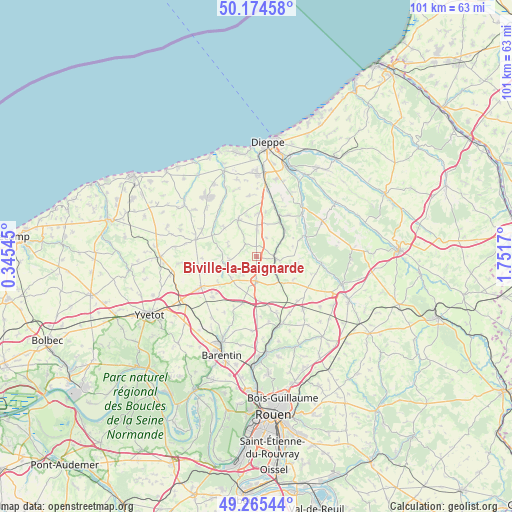
Biville-la-Baignarde GPS coordinates[2]
49° 43' 19.704" North, 1° 2' 54.852" East
| Map corner | latitude | longitude |
|---|---|---|
| Upper-left | 50.17458°, | 0.34545° |
| Center: | 49.72214°, | 1.04857° |
| Lower-right: | 49.26544°, | 1.7517° |
| Map W x H: | 101.1×101.1 km | = 62.8×62.8mi |
| max Lat: | 51.07786° ⇑8.3% North |
| Biville-la-Baignarde: | 49.72214° |
| min Lat: | ⇓91.7% South 41.3874° |
| min Long | Biville-la-Baig | max Long |
| -5.08615° | 1.04857° | 9.52242° |
| W 31.7%⇐ | ⇒68.3% E |
Elevation
Elevation of Biville-la-Baignarde is 135 m = 443 ft, and this is 58.7 m = 193 ft below average elevation for this country.
| Max E: |
2333 m = 7654 ft | 49.2% |
| Avg. | 193.7 m = 635 ft | |
| Biville-la-Baignarde | 135 m = 443 ft | |
Min E: |
-1 m = -3 ft | 50.8% |
See also: France elevation on elevation.city.
Geographical zone
Biville-la-Baignarde is located in North temperate zone (between Tropic of Cancer and the Arctic Circle). Distance of this North polar circle is 1872.6 km =1163.6 mi to North.| Distance of | km | miles | from Biville-la-Baignarde |
|---|---|---|---|
| North Pole | 4478.5 | 2782.8 | to North |
| Arctic Circle | 1872.6 | 1163.6 | to North |
| Tropic Cancer | 2922.7 | 1816.1 | to South |
| Equator | 5528.6 | 3435.3 | to South |


Nearby cities:
15 places around Biville-la-Baignarde: (largest is in red/bold)
• Auffay
3.7 km =2.3 mi,  95°
95°
• Auppegard
12 km =7.5 mi,  352°
352°
• Bacqueville-en-Caux
8.1 km =5 mi,  334°
334°
• Grugny
11.7 km =7.3 mi,  159°
159°
• Heugleville-sur-Scie
3.1 km =1.9 mi,  68°
68°
• La Houssaye-Béranger
10.2 km =6.3 mi,  165°
165°
• Longueville-sur-Scie
8.9 km =5.5 mi,  29°
29°
• Orival
11.3 km =7 mi,  88°
88°
• Saint-Laurent-en-Caux
12.5 km =7.8 mi,  284°
284°
• Saint-Maclou-de-Folleville
6.1 km =3.8 mi,  137°
137°
• Saint-Ouen-du-Breuil
9.7 km =6 mi,  196°
196°
• Torcy-le-Grand
12.5 km =7.8 mi,  46°
46°
• Tôtes
4.6 km =2.9 mi,  181°
181°
• Vibeuf
10.9 km =6.8 mi,  252°
252°
• Étaimpuis
10.9 km =6.8 mi, 142°
Sources, notices
• [Note1] Compared only with cities in France existing in our database
• [Src1] Map data: © OpenStreetMap contributors (CC-BY-SA)
• [Src2] Other city data from geonames.org with taken over terms of usage.
• [Src3] Geographical zone / Annual Mean Temperature by Robert A. Rohde @ Wikipedia
