Louvigny geodata
Louvigny (Normandy) is a populated place; located in France in Europe/Paris (GMT+2) time zone. With population of 2,222 people, there are 4322 cities with bigger population in this country. Compared to other cities in France, 83.4% of cities are located further ↓South; 82% of cities are located further →East and 96% of cities have higher elevation than Louvigny. Note1
Administrative division(s):
- Level 1: Normandy
- Level 2: Calvados
- Level 3: Arrondissement de Caen
- Level 4: Louvigny


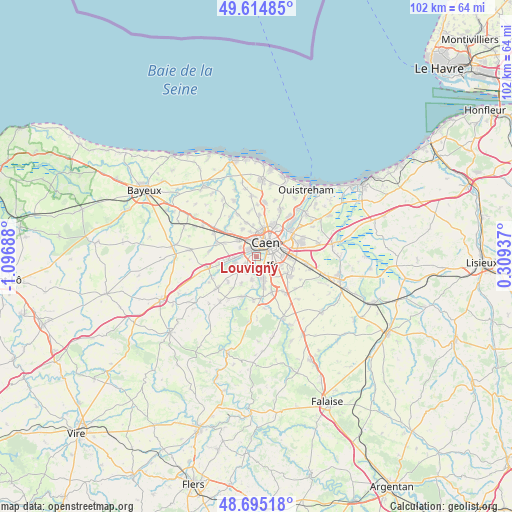
Louvigny GPS coordinates[2]
49° 9' 25.74" North, 0° 23' 37.536" West
| Map corner | latitude | longitude |
|---|---|---|
| Upper-left | 49.61485°, | -1.09688° |
| Center: | 49.15715°, | -0.39376° |
| Lower-right: | 48.69518°, | 0.30937° |
| Map W x H: | 102.3×102.3 km | = 63.6×63.6mi |
| max Lat: | 51.07786° ⇑16.6% North |
| Louvigny: | 49.15715° |
| min Lat: | ⇓83.4% South 41.3874° |
| min Long | Louvigny | max Long |
| -5.08615° | -0.39376° | 9.52242° |
| W 18%⇐ | ⇒82% E |
Elevation
Elevation of Louvigny is 14 m = 46 ft, and this is 179.7 m = 590 ft below average elevation for this country.
| Max E: |
2333 m = 7654 ft | 96% |
| Avg. | 193.7 m = 635 ft | |
| Louvigny | 14 m = 46 ft | |
Min E: |
-1 m = -3 ft | 4% |
See also: France elevation on elevation.city.
Geographical zone
Louvigny is located in North temperate zone (between Tropic of Cancer and the Arctic Circle). Distance of this North polar circle is 1935.4 km =1202.6 mi to North.| Distance of | km | miles | from Louvigny |
|---|---|---|---|
| North Pole | 4541.3 | 2821.8 | to North |
| Arctic Circle | 1935.4 | 1202.6 | to North |
| Tropic Cancer | 2859.8 | 1777 | to South |
| Equator | 5465.8 | 3396.3 | to South |


Nearby cities:
15 places around Louvigny: (largest is in red/bold)
• Authie
6.1 km =3.8 mi,  333°
333°
• Bretteville-sur-Odon
1.9 km =1.2 mi,  301°
301°
• Caen
4.1 km =2.5 mi,  38°
38°
• Carpiquet
4.9 km =3 mi,  309°
309°
• Cormelles-le-Royal
4.6 km =2.9 mi,  94°
94°
• Fleury-sur-Orne
1.7 km =1.1 mi,  125°
125°
• Fontaine-Étoupefour
4.6 km =2.9 mi,  254°
254°
• Ifs
3.8 km =2.4 mi,  120°
120°
• Maltot
3.9 km =2.4 mi,  212°
212°
• Mondeville
5.6 km =3.5 mi,  69°
69°
• Saint-André-sur-Orne
4.5 km =2.8 mi,  169°
169°
• Saint-Germain-la-Blanche-Herbe
3 km =1.9 mi,  345°
345°
• Saint-Martin-de-Fontenay
4.9 km =3 mi,  162°
162°
• Verson
4.6 km =2.9 mi,  266°
266°
• Éterville
2.7 km =1.7 mi,  237°
237°
Sources, notices
• [Note1] Compared only with cities in France existing in our database
• [Src1] Map data: © OpenStreetMap contributors (CC-BY-SA)
• [Src2] Other city data from geonames.org with taken over terms of usage.
• [Src3] Geographical zone / Annual Mean Temperature by Robert A. Rohde @ Wikipedia
