Maltot geodata
Maltot (Normandy) is a populated place; located in France in Europe/Paris (GMT+2) time zone. With population of 703 people, there are 11764 cities with bigger population in this country. Compared to other cities in France, 82.8% of cities are located further ↓South; 82.4% of cities are located further →East and 77% of cities have higher elevation than Maltot. Note1
Administrative division(s):
- Level 1: Normandy
- Level 2: Calvados
- Level 3: Arrondissement de Caen
- Level 4: Maltot


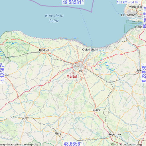
Maltot GPS coordinates[2]
49° 7' 40.224" North, 0° 25' 21.864" West
| Map corner | latitude | longitude |
|---|---|---|
| Upper-left | 49.58581°, | -1.12587° |
| Center: | 49.12784°, | -0.42274° |
| Lower-right: | 48.6656°, | 0.28038° |
| Map W x H: | 102.3×102.3 km | = 63.6×63.6mi |
| max Lat: | 51.07786° ⇑17.2% North |
| Maltot: | 49.12784° |
| min Lat: | ⇓82.8% South 41.3874° |
| min Long | Maltot | max Long |
| -5.08615° | -0.42274° | 9.52242° |
| W 17.6%⇐ | ⇒82.4% E |
Elevation
Elevation of Maltot is 62 m = 203 ft, and this is 131.7 m = 432 ft below average elevation for this country.
| Max E: |
2333 m = 7654 ft | 77% |
| Avg. | 193.7 m = 635 ft | |
| Maltot | 62 m = 203 ft | |
Min E: |
-1 m = -3 ft | 23% |
See also: France elevation on elevation.city.
Geographical zone
Maltot is located in North temperate zone (between Tropic of Cancer and the Arctic Circle). Distance of this North polar circle is 1938.7 km =1204.7 mi to North.| Distance of | km | miles | from Maltot |
|---|---|---|---|
| North Pole | 4544.6 | 2823.9 | to North |
| Arctic Circle | 1938.7 | 1204.7 | to North |
| Tropic Cancer | 2856.6 | 1775 | to South |
| Equator | 5462.5 | 3394.2 | to South |


Nearby cities:
15 places around Maltot: (largest is in red/bold)
• Amayé-sur-Orne
4.9 km =3 mi,  193°
193°
• Baron-sur-Odon
4 km =2.5 mi,  276°
276°
• Bretteville-sur-Odon
4.3 km =2.7 mi,  5°
5°
• Bully
3.1 km =1.9 mi,  160°
160°
• Esquay-Notre-Dame
4 km =2.5 mi,  243°
243°
• Fleury-sur-Orne
4.2 km =2.6 mi,  56°
56°
• Fontaine-Étoupefour
3.1 km =1.9 mi,  310°
310°
• Louvigny
3.9 km =2.4 mi,  32°
32°
• May-sur-Orne
4.6 km =2.9 mi,  130°
130°
• Mouen
4.9 km =3 mi,  295°
295°
• Saint-André-sur-Orne
3.2 km =2 mi,  111°
111°
• Saint-Martin-de-Fontenay
3.8 km =2.4 mi, 111°
• Verson
3.8 km =2.4 mi,  320°
320°
• Vieux
2.4 km =1.5 mi,  199°
199°
• Éterville
1.8 km =1.1 mi,  354°
354°
Sources, notices
• [Note1] Compared only with cities in France existing in our database
• [Src1] Map data: © OpenStreetMap contributors (CC-BY-SA)
• [Src2] Other city data from geonames.org with taken over terms of usage.
• [Src3] Geographical zone / Annual Mean Temperature by Robert A. Rohde @ Wikipedia
