Vernéville geodata
Vernéville (Grand Est) is a populated place; located in France in Europe/Paris (GMT+2) time zone. With population of 636 people, there are 12726 cities with bigger population in this country. Compared to other cities in France, 83.2% of cities are located further ↓South; 87.1% of cities are located further ←West and 81.9% of cities have lower elevation than Vernéville. Note1
Administrative division(s):
- Level 1: Grand Est
- Level 2: Moselle
- Level 3: Arrondissement de Metz
- Level 4: Vernéville


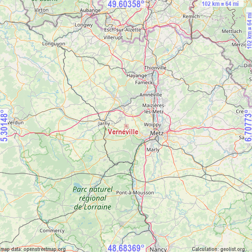
Vernéville GPS coordinates[2]
49° 8' 44.772" North, 6° 0' 16.596" East
| Map corner | latitude | longitude |
|---|---|---|
| Upper-left | 49.60358°, | 5.30148° |
| Center: | 49.14577°, | 6.00461° |
| Lower-right: | 48.68369°, | 6.70773° |
| Map W x H: | 102.3×102.3 km | = 63.6×63.6mi |
| max Lat: | 51.07786° ⇑16.8% North |
| Vernéville: | 49.14577° |
| min Lat: | ⇓83.2% South 41.3874° |
| min Long | Vernéville | max Long |
| -5.08615° | 6.00461° | 9.52242° |
| W 87.1%⇐ | ⇒12.9% E |
Elevation
Elevation of Vernéville is 310 m = 1017 ft, and this is 116.3 m = 382 ft above average elevation for this country.
| Max E: |
2333 m = 7654 ft | 18.1% |
| Vernéville | 310 m 1017 ft | |
| Avg. | 193.7 m = 635 ft | |
Min E: |
-1 m = -3 ft | 81.9% |
See also: France elevation on elevation.city.
Geographical zone
Vernéville is located in North temperate zone (between Tropic of Cancer and the Arctic Circle). Distance of this North polar circle is 1936.7 km =1203.4 mi to North.| Distance of | km | miles | from Vernéville |
|---|---|---|---|
| North Pole | 4542.6 | 2822.6 | to North |
| Arctic Circle | 1936.7 | 1203.4 | to North |
| Tropic Cancer | 2858.6 | 1776.3 | to South |
| Equator | 5464.5 | 3395.5 | to South |


Nearby cities:
15 places around Vernéville: (largest is in red/bold)
• Amanvillers
3.8 km =2.4 mi,  49°
49°
• Auboué
7.6 km =4.7 mi,  344°
344°
• Batilly
4.1 km =2.5 mi,  319°
319°
• Châtel-Saint-Germain
6.1 km =3.8 mi,  115°
115°
• Doncourt-lès-Conflans
5.2 km =3.2 mi,  265°
265°
• Giraumont
7.1 km =4.4 mi,  292°
292°
• Gravelotte
4.4 km =2.7 mi,  155°
155°
• Lessy
7.3 km =4.5 mi,  114°
114°
• Moineville
7.9 km =4.9 mi,  326°
326°
• Montois-la-Montagne
8 km =5 mi,  8°
8°
• Roncourt
6.8 km =4.2 mi,  22°
22°
• Rozérieulles
7.1 km =4.4 mi,  127°
127°
• Saint-Privat-la-Montagne
5.3 km =3.3 mi,  28°
28°
• Sainte-Marie-aux-Chênes
5.2 km =3.2 mi,  357°
357°
• Saulny
7.7 km =4.8 mi,  80°
80°
Sources, notices
• [Note1] Compared only with cities in France existing in our database
• [Src1] Map data: © OpenStreetMap contributors (CC-BY-SA)
• [Src2] Other city data from geonames.org with taken over terms of usage.
• [Src3] Geographical zone / Annual Mean Temperature by Robert A. Rohde @ Wikipedia
