Auboué geodata
Auboué (Grand Est) is a populated place; located in France in Europe/Paris (GMT+2) time zone. With population of 2,890 people, there are 3374 cities with bigger population in this country. Compared to other cities in France, 84.5% of cities are located further ↓South; 86.8% of cities are located further ←West and 72% of cities have lower elevation than Auboué. Note1
Administrative division(s):
- Level 1: Grand Est
- Level 2: Meurthe-et-Moselle
- Level 3: Arrondissement de Briey
- Level 4: Auboué


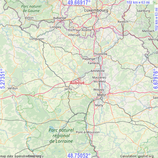
Auboué GPS coordinates[2]
49° 12' 43.128" North, 5° 58' 35.868" East
| Map corner | latitude | longitude |
|---|---|---|
| Upper-left | 49.66917°, | 5.27351° |
| Center: | 49.21198°, | 5.97663° |
| Lower-right: | 48.75052°, | 6.67976° |
| Map W x H: | 102.1×102.1 km | = 63.4×63.4mi |
| max Lat: | 51.07786° ⇑15.5% North |
| Auboué: | 49.21198° |
| min Lat: | ⇓84.5% South 41.3874° |
| min Long | Auboué | max Long |
| -5.08615° | 5.97663° | 9.52242° |
| W 86.8%⇐ | ⇒13.2% E |
Elevation
Elevation of Auboué is 230 m = 755 ft, and this is 36.3 m = 119 ft above average elevation for this country.
| Max E: |
2333 m = 7654 ft | 28% |
| Auboué | 230 m 755 ft | |
| Avg. | 193.7 m = 635 ft | |
Min E: |
-1 m = -3 ft | 72% |
See also: France elevation on elevation.city.
Geographical zone
Auboué is located in North temperate zone (between Tropic of Cancer and the Arctic Circle). Distance of this North polar circle is 1929.3 km =1198.8 mi to North.| Distance of | km | miles | from Auboué |
|---|---|---|---|
| North Pole | 4535.2 | 2818 | to North |
| Arctic Circle | 1929.3 | 1198.8 | to North |
| Tropic Cancer | 2865.9 | 1780.8 | to South |
| Equator | 5471.9 | 3400.1 | to South |


Nearby cities:
15 places around Auboué: (largest is in red/bold)
• Batilly
4.3 km =2.7 mi,  187°
187°
• Briey
4.9 km =3 mi,  327°
327°
• Giraumont
6.4 km =4 mi,  224°
224°
• Hatrize
5.4 km =3.4 mi,  245°
245°
• Homécourt
1.5 km =0.9 mi,  49°
49°
• Jœuf
3.8 km =2.4 mi, 50°
• Lantéfontaine
6.6 km =4.1 mi,  308°
308°
• Moineville
2.5 km =1.6 mi, 252°
• Montois-la-Montagne
3.3 km =2.1 mi,  80°
80°
• Moutiers
2.5 km =1.6 mi,  340°
340°
• Moyeuvre-Grande
6.7 km =4.2 mi, 47°
• Roncourt
4.8 km =3 mi,  102°
102°
• Saint-Privat-la-Montagne
5.3 km =3.3 mi,  120°
120°
• Sainte-Marie-aux-Chênes
2.8 km =1.7 mi,  139°
139°
• Valleroy
2.9 km =1.8 mi,  264°
264°
Sources, notices
• [Note1] Compared only with cities in France existing in our database
• [Src1] Map data: © OpenStreetMap contributors (CC-BY-SA)
• [Src2] Other city data from geonames.org with taken over terms of usage.
• [Src3] Geographical zone / Annual Mean Temperature by Robert A. Rohde @ Wikipedia
