Verneuil-sur-Vienne geodata
Verneuil-sur-Vienne (Nouvelle-Aquitaine) is a populated place; located in France in Europe/Paris (GMT+2) time zone. With population of 3,594 people, there are 2719 cities with bigger population in this country. Compared to other cities in France, 68.5% of cities are located further ↑North; 67.6% of cities are located further →East and 82.2% of cities have lower elevation than Verneuil-sur-Vienne. Note1
Administrative division(s):
- Level 1: Nouvelle-Aquitaine
- Level 2: Haute-Vienne
- Level 3: Arrondissement de Limoges
- Level 4: Verneuil-sur-Vienne


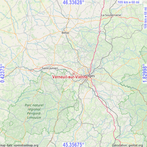
Verneuil-sur-Vienne GPS coordinates[2]
45° 50' 55.212" North, 1° 7' 36.696" East
| Map corner | latitude | longitude |
|---|---|---|
| Upper-left | 46.33628°, | 0.42373° |
| Center: | 45.84867°, | 1.12686° |
| Lower-right: | 45.35675°, | 1.82998° |
| Map W x H: | 108.9×108.9 km | = 67.7×67.7mi |
| max Lat: | 51.07786° ⇑68.5% North |
| Verneuil-sur-Vienne: | 45.84867° |
| min Lat: | ⇓31.5% South 41.3874° |
| min Long | Verneuil-sur-Vi | max Long |
| -5.08615° | 1.12686° | 9.52242° |
| W 32.4%⇐ | ⇒67.6% E |
Elevation
Elevation of Verneuil-sur-Vienne is 312 m = 1024 ft, and this is 118.3 m = 388 ft above average elevation for this country.
| Max E: |
2333 m = 7654 ft | 17.8% |
| Verneuil-sur-Vienne | 312 m 1024 ft | |
| Avg. | 193.7 m = 635 ft | |
Min E: |
-1 m = -3 ft | 82.2% |
See also: France elevation on elevation.city.
Geographical zone
Verneuil-sur-Vienne is located in North temperate zone (between Tropic of Cancer and the Arctic Circle). Distance of this North polar circle is 2303.3 km =1431.2 mi to North.| Distance of | km | miles | from Verneuil-sur-Vienne |
|---|---|---|---|
| North Pole | 4909.2 | 3050.4 | to North |
| Arctic Circle | 2303.3 | 1431.2 | to North |
| Tropic Cancer | 2492 | 1548.5 | to South |
| Equator | 5097.9 | 3167.7 | to South |


Nearby cities:
15 places around Verneuil-sur-Vienne: (largest is in red/bold)
• Aixe-sur-Vienne
5.8 km =3.6 mi,  173°
173°
• Beynac
9.6 km =6 mi,  160°
160°
• Cognac-la-Forêt
9.2 km =5.7 mi,  259°
259°
• Condat-sur-Vienne
10.2 km =6.3 mi,  127°
127°
• Couzeix
9.2 km =5.7 mi,  70°
70°
• Isle
9.1 km =5.7 mi,  122°
122°
• Limoges
9.5 km =5.9 mi,  100°
100°
• Nieul
9.4 km =5.8 mi,  23°
23°
• Peyrilhac
11.4 km =7.1 mi,  2°
2°
• Saint-Gence
8.2 km =5.1 mi,  5°
5°
• Saint-Martin-le-Vieux
11.6 km =7.2 mi,  183°
183°
• Saint-Priest-sous-Aixe
4.1 km =2.5 mi,  210°
210°
• Saint-Victurnien
9.4 km =5.8 mi,  290°
290°
• Séreilhac
9.5 km =5.9 mi,  201°
201°
• Veyrac
5.6 km =3.5 mi,  343°
343°
Sources, notices
• [Note1] Compared only with cities in France existing in our database
• [Src1] Map data: © OpenStreetMap contributors (CC-BY-SA)
• [Src2] Other city data from geonames.org with taken over terms of usage.
• [Src3] Geographical zone / Annual Mean Temperature by Robert A. Rohde @ Wikipedia
