Veyrac geodata
Veyrac (Nouvelle-Aquitaine) is a populated place; located in France in Europe/Paris (GMT+2) time zone. With population of 1,900 people, there are 5031 cities with bigger population in this country. Compared to other cities in France, 67.7% of cities are located further ↑North; 67.8% of cities are located further →East and 81.9% of cities have lower elevation than Veyrac. Note1
Administrative division(s):
- Level 1: Nouvelle-Aquitaine
- Level 2: Haute-Vienne
- Level 3: Arrondissement de Limoges
- Level 4: Veyrac


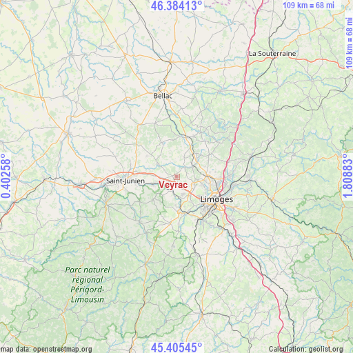
Veyrac GPS coordinates[2]
45° 53' 49.02" North, 1° 6' 20.52" East
| Map corner | latitude | longitude |
|---|---|---|
| Upper-left | 46.38413°, | 0.40258° |
| Center: | 45.89695°, | 1.1057° |
| Lower-right: | 45.40545°, | 1.80883° |
| Map W x H: | 108.8×108.8 km | = 67.6×67.6mi |
| max Lat: | 51.07786° ⇑67.7% North |
| Veyrac: | 45.89695° |
| min Lat: | ⇓32.3% South 41.3874° |
| min Long | Veyrac | max Long |
| -5.08615° | 1.1057° | 9.52242° |
| W 32.2%⇐ | ⇒67.8% E |
Elevation
Elevation of Veyrac is 310 m = 1017 ft, and this is 116.3 m = 382 ft above average elevation for this country.
| Max E: |
2333 m = 7654 ft | 18.1% |
| Veyrac | 310 m 1017 ft | |
| Avg. | 193.7 m = 635 ft | |
Min E: |
-1 m = -3 ft | 81.9% |
See also: France elevation on elevation.city.
Geographical zone
Veyrac is located in North temperate zone (between Tropic of Cancer and the Arctic Circle). Distance of this North polar circle is 2297.9 km =1427.8 mi to North.| Distance of | km | miles | from Veyrac |
|---|---|---|---|
| North Pole | 4903.8 | 3047.1 | to North |
| Arctic Circle | 2297.9 | 1427.8 | to North |
| Tropic Cancer | 2497.3 | 1551.7 | to South |
| Equator | 5103.3 | 3171 | to South |


Nearby cities:
15 places around Veyrac: (largest is in red/bold)
• Aixe-sur-Vienne
11.4 km =7.1 mi,  168°
168°
• Chaptelat
11.9 km =7.4 mi,  82°
82°
• Cieux
11.5 km =7.1 mi,  336°
336°
• Cognac-la-Forêt
10.3 km =6.4 mi,  226°
226°
• Couzeix
10.5 km =6.5 mi,  102°
102°
• Javerdat
11.3 km =7 mi,  304°
304°
• Nieul
6.3 km =3.9 mi,  58°
58°
• Oradour-sur-Glane
7.1 km =4.4 mi, 304°
• Peyrilhac
6.4 km =4 mi,  20°
20°
• Saint-Brice-sur-Vienne
11.9 km =7.4 mi,  260°
260°
• Saint-Gence
3.7 km =2.3 mi,  42°
42°
• Saint-Jouvent
10.2 km =6.3 mi,  48°
48°
• Saint-Priest-sous-Aixe
8.9 km =5.5 mi,  182°
182°
• Saint-Victurnien
7.5 km =4.7 mi,  253°
253°
• Verneuil-sur-Vienne
5.6 km =3.5 mi,  163°
163°
Sources, notices
• [Note1] Compared only with cities in France existing in our database
• [Src1] Map data: © OpenStreetMap contributors (CC-BY-SA)
• [Src2] Other city data from geonames.org with taken over terms of usage.
• [Src3] Geographical zone / Annual Mean Temperature by Robert A. Rohde @ Wikipedia
