Saint-Victurnien geodata
Saint-Victurnien (Nouvelle-Aquitaine) is a populated place; located in France in Europe/Paris (GMT+2) time zone. With population of 1,543 people, there are 6040 cities with bigger population in this country. Compared to other cities in France, 68% of cities are located further ↑North; 68.7% of cities are located further →East and 65% of cities have lower elevation than Saint-Victurnien. Note1
Administrative division(s):
- Level 1: Nouvelle-Aquitaine
- Level 2: Haute-Vienne
- Level 3: Arrondissement de Rochechouart
- Level 4: Saint-Victurnien


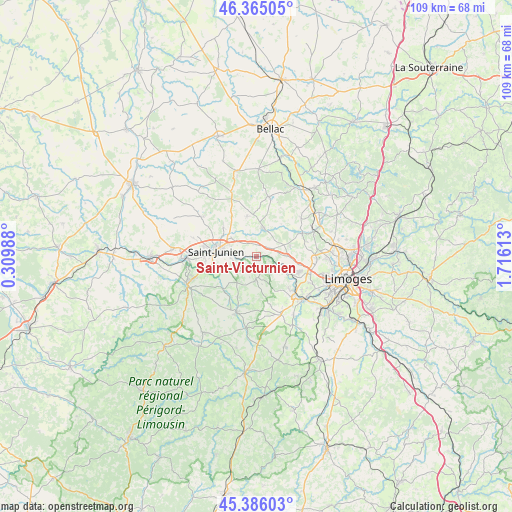
Saint-Victurnien GPS coordinates[2]
45° 52' 39.72" North, 1° 0' 46.836" East
| Map corner | latitude | longitude |
|---|---|---|
| Upper-left | 46.36505°, | 0.30988° |
| Center: | 45.8777°, | 1.01301° |
| Lower-right: | 45.38603°, | 1.71613° |
| Map W x H: | 108.9×108.9 km | = 67.7×67.7mi |
| max Lat: | 51.07786° ⇑68% North |
| Saint-Victurnien: | 45.8777° |
| min Lat: | ⇓32% South 41.3874° |
| min Long | Saint-Victurnie | max Long |
| -5.08615° | 1.01301° | 9.52242° |
| W 31.3%⇐ | ⇒68.7% E |
Elevation
Elevation of Saint-Victurnien is 194 m = 636 ft, and this is 0.30000000000001 m = 1 ft above average elevation for this country.
| Max E: |
2333 m = 7654 ft | 35% |
| Saint-Victurnien | 194 m 636 ft | |
| Avg. | 193.7 m = 635 ft | |
Min E: |
-1 m = -3 ft | 65% |
See also: France elevation on elevation.city.
Geographical zone
Saint-Victurnien is located in North temperate zone (between Tropic of Cancer and the Arctic Circle). Distance of this North polar circle is 2300.1 km =1429.2 mi to North.| Distance of | km | miles | from Saint-Victurnien |
|---|---|---|---|
| North Pole | 4905.9 | 3048.4 | to North |
| Arctic Circle | 2300.1 | 1429.2 | to North |
| Tropic Cancer | 2495.2 | 1550.4 | to South |
| Equator | 5101.1 | 3169.7 | to South |


Nearby cities:
15 places around Saint-Victurnien: (largest is in red/bold)
• Chaillac-sur-Vienne
10.9 km =6.8 mi,  270°
270°
• Cieux
12.9 km =8 mi,  11°
11°
• Cognac-la-Forêt
4.9 km =3 mi,  182°
182°
• Javerdat
8.8 km =5.5 mi,  345°
345°
• Oradour-sur-Glane
6.3 km =3.9 mi, 12°
• Peyrilhac
12.4 km =7.7 mi,  49°
49°
• Saint-Auvent
10.2 km =6.3 mi,  217°
217°
• Saint-Brice-sur-Vienne
4.6 km =2.9 mi, 272°
• Saint-Cyr
9.6 km =6 mi,  206°
206°
• Saint-Gence
10.8 km =6.7 mi,  63°
63°
• Saint-Junien
8.7 km =5.4 mi,  277°
277°
• Saint-Laurent-sur-Gorre
12.8 km =8 mi,  199°
199°
• Saint-Priest-sous-Aixe
9.5 km =5.9 mi,  134°
134°
• Verneuil-sur-Vienne
9.4 km =5.8 mi,  110°
110°
• Veyrac
7.5 km =4.7 mi,  73°
73°
Sources, notices
• [Note1] Compared only with cities in France existing in our database
• [Src1] Map data: © OpenStreetMap contributors (CC-BY-SA)
• [Src2] Other city data from geonames.org with taken over terms of usage.
• [Src3] Geographical zone / Annual Mean Temperature by Robert A. Rohde @ Wikipedia
