Veigné geodata
Veigné (Centre) is a populated place; located in France in Europe/Paris (GMT+2) time zone. With population of 5,771 people, there are 1708 cities with bigger population in this country. Compared to other cities in France, 51.7% of cities are located further ↑North; 71.1% of cities are located further →East and 72.3% of cities have higher elevation than Veigné. Note1
Administrative division(s):
- Level 1: Centre
- Level 2: Département d'Indre-et-Loire
- Level 3: Arrondissement de Tours
- Level 4: Veigné


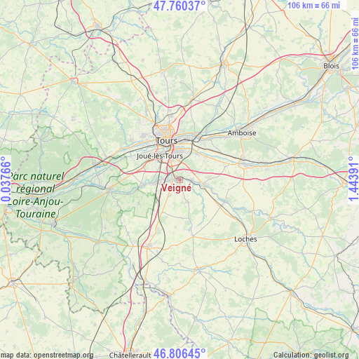
Veigné GPS coordinates[2]
47° 17' 8.016" North, 0° 44' 26.844" East
| Map corner | latitude | longitude |
|---|---|---|
| Upper-left | 47.76037°, | 0.03766° |
| Center: | 47.28556°, | 0.74079° |
| Lower-right: | 46.80645°, | 1.44391° |
| Map W x H: | 106.1×106.1 km | = 65.9×65.9mi |
| max Lat: | 51.07786° ⇑51.7% North |
| Veigné: | 47.28556° |
| min Lat: | ⇓48.3% South 41.3874° |
| min Long | Veigné | max Long |
| -5.08615° | 0.74079° | 9.52242° |
| W 28.9%⇐ | ⇒71.1% E |
Elevation
Elevation of Veigné is 73 m = 240 ft, and this is 120.7 m = 396 ft below average elevation for this country.
| Max E: |
2333 m = 7654 ft | 72.3% |
| Avg. | 193.7 m = 635 ft | |
| Veigné | 73 m = 240 ft | |
Min E: |
-1 m = -3 ft | 27.7% |
See also: France elevation on elevation.city.
Geographical zone
Veigné is located in North temperate zone (between Tropic of Cancer and the Arctic Circle). Distance of this North polar circle is 2143.5 km =1331.9 mi to North.| Distance of | km | miles | from Veigné |
|---|---|---|---|
| North Pole | 4749.4 | 2951.1 | to North |
| Arctic Circle | 2143.5 | 1331.9 | to North |
| Tropic Cancer | 2651.7 | 1647.7 | to South |
| Equator | 5257.7 | 3267 | to South |


Nearby cities:
15 places around Veigné: (largest is in red/bold)
• Artannes-sur-Indre
10.7 km =6.6 mi,  263°
263°
• Azay-sur-Cher
10.6 km =6.6 mi,  47°
47°
• Chambray-lès-Tours
6.2 km =3.9 mi,  332°
332°
• Cormery
7.4 km =4.6 mi,  105°
105°
• Esvres
3.4 km =2.1 mi,  90°
90°
• Joué-lès-Tours
9.2 km =5.7 mi,  323°
323°
• Larçay
9.5 km =5.9 mi,  18°
18°
• Montbazon
3.1 km =1.9 mi,  265°
265°
• Monts
8.8 km =5.5 mi, 263°
• Saint-Avertin
8.7 km =5.4 mi,  359°
359°
• Saint-Branchs
7 km =4.3 mi,  159°
159°
• Sorigny
5.8 km =3.6 mi,  216°
216°
• Tauxigny
10.7 km =6.6 mi,  138°
138°
• Truyes
8.5 km =5.3 mi,  99°
99°
• Véretz
9.3 km =5.8 mi,  31°
31°
Sources, notices
• [Note1] Compared only with cities in France existing in our database
• [Src1] Map data: © OpenStreetMap contributors (CC-BY-SA)
• [Src2] Other city data from geonames.org with taken over terms of usage.
• [Src3] Geographical zone / Annual Mean Temperature by Robert A. Rohde @ Wikipedia
