Azay-sur-Cher geodata
Azay-sur-Cher (Centre) is a populated place; located in France in Europe/Paris (GMT+2) time zone. With population of 2,873 people, there are 3398 cities with bigger population in this country. Compared to other cities in France, 50.8% of cities are located further ↑North; 70.2% of cities are located further →East and 76.2% of cities have higher elevation than Azay-sur-Cher. Note1
Administrative division(s):
- Level 1: Centre
- Level 2: Département d'Indre-et-Loire
- Level 3: Arrondissement de Tours
- Level 4: Azay-sur-Cher


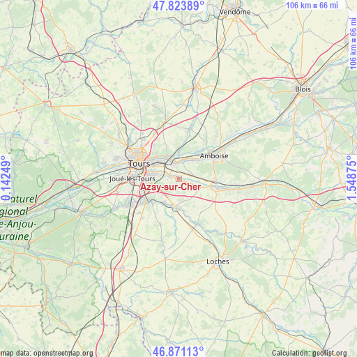
Azay-sur-Cher GPS coordinates[2]
47° 20' 58.776" North, 0° 50' 44.232" East
| Map corner | latitude | longitude |
|---|---|---|
| Upper-left | 47.82389°, | 0.14249° |
| Center: | 47.34966°, | 0.84562° |
| Lower-right: | 46.87113°, | 1.54875° |
| Map W x H: | 105.9×105.9 km | = 65.8×65.8mi |
| max Lat: | 51.07786° ⇑50.8% North |
| Azay-sur-Cher: | 47.34966° |
| min Lat: | ⇓49.2% South 41.3874° |
| min Long | Azay-sur-Cher | max Long |
| -5.08615° | 0.84562° | 9.52242° |
| W 29.8%⇐ | ⇒70.2% E |
Elevation
Elevation of Azay-sur-Cher is 64 m = 210 ft, and this is 129.7 m = 426 ft below average elevation for this country.
| Max E: |
2333 m = 7654 ft | 76.2% |
| Avg. | 193.7 m = 635 ft | |
| Azay-sur-Cher | 64 m = 210 ft | |
Min E: |
-1 m = -3 ft | 23.8% |
See also: France elevation on elevation.city.
Geographical zone
Azay-sur-Cher is located in North temperate zone (between Tropic of Cancer and the Arctic Circle). Distance of this North polar circle is 2136.4 km =1327.5 mi to North.| Distance of | km | miles | from Azay-sur-Cher |
|---|---|---|---|
| North Pole | 4742.3 | 2946.7 | to North |
| Arctic Circle | 2136.4 | 1327.5 | to North |
| Tropic Cancer | 2658.9 | 1652.2 | to South |
| Equator | 5264.8 | 3271.4 | to South |


Nearby cities:
15 places around Azay-sur-Cher: (largest is in red/bold)
• Athée-sur-Cher
6.3 km =3.9 mi,  121°
121°
• Dierre
8.4 km =5.2 mi,  93°
93°
• Esvres
8.4 km =5.2 mi,  212°
212°
• La Ville-aux-Dames
7.7 km =4.8 mi,  311°
311°
• Larçay
5.2 km =3.2 mi,  291°
291°
• Lussault-sur-Loire
7.3 km =4.5 mi,  46°
46°
• Montlouis-sur-Loire
4.4 km =2.7 mi,  346°
346°
• Noizay
8.8 km =5.5 mi,  23°
23°
• Saint-Avertin
8.1 km =5 mi,  280°
280°
• Saint-Martin-le-Beau
4.9 km =3 mi,  82°
82°
• Saint-Pierre-des-Corps
8.4 km =5.2 mi,  299°
299°
• Truyes
8.5 km =5.3 mi,  176°
176°
• Vernou-sur-Brenne
7.8 km =4.8 mi,  1°
1°
• Vouvray
7.7 km =4.8 mi,  332°
332°
• Véretz
3.1 km =1.9 mi, 285°
Sources, notices
• [Note1] Compared only with cities in France existing in our database
• [Src1] Map data: © OpenStreetMap contributors (CC-BY-SA)
• [Src2] Other city data from geonames.org with taken over terms of usage.
• [Src3] Geographical zone / Annual Mean Temperature by Robert A. Rohde @ Wikipedia
