Joué-lès-Tours geodata
Joué-lès-Tours (Centre) is a populated place; located in France in Europe/Paris (GMT+2) time zone. With population of 37,466 people, there are 203 cities with bigger population in this country. Compared to other cities in France, 50.7% of cities are located further ↑North; 71.7% of cities are located further →East and 67.8% of cities have higher elevation than Joué-lès-Tours. Note1
Administrative division(s):
- Level 1: Centre
- Level 2: Département d'Indre-et-Loire
- Level 3: Arrondissement de Tours
- Level 4: Joué-lès-Tours


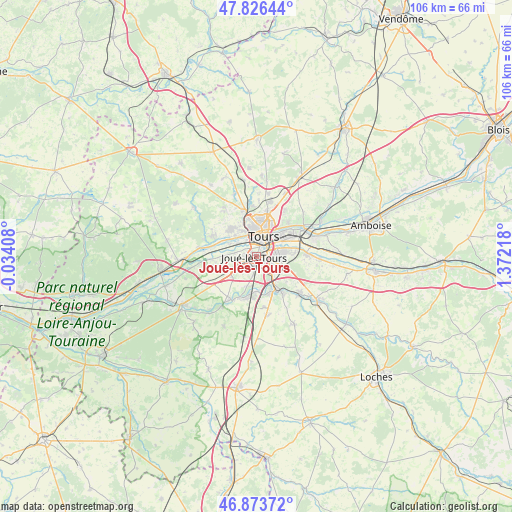
Joué-lès-Tours GPS coordinates[2]
47° 21' 8.028" North, 0° 40' 8.58" East
| Map corner | latitude | longitude |
|---|---|---|
| Upper-left | 47.82644°, | -0.03408° |
| Center: | 47.35223°, | 0.66905° |
| Lower-right: | 46.87372°, | 1.37218° |
| Map W x H: | 105.9×105.9 km | = 65.8×65.8mi |
| max Lat: | 51.07786° ⇑50.7% North |
| Joué-lès-Tours: | 47.35223° |
| min Lat: | ⇓49.3% South 41.3874° |
| min Long | Joué-lès-Tour | max Long |
| -5.08615° | 0.66905° | 9.52242° |
| W 28.3%⇐ | ⇒71.7% E |
Elevation
Elevation of Joué-lès-Tours is 83 m = 272 ft, and this is 110.7 m = 363 ft below average elevation for this country.
| Max E: |
2333 m = 7654 ft | 67.8% |
| Avg. | 193.7 m = 635 ft | |
| Joué-lès-Tours | 83 m = 272 ft | |
Min E: |
-1 m = -3 ft | 32.2% |
See also: France elevation on elevation.city.
Geographical zone
Joué-lès-Tours is located in North temperate zone (between Tropic of Cancer and the Arctic Circle). Distance of this North polar circle is 2136.1 km =1327.3 mi to North.| Distance of | km | miles | from Joué-lès-Tours |
|---|---|---|---|
| North Pole | 4742 | 2946.5 | to North |
| Arctic Circle | 2136.1 | 1327.3 | to North |
| Tropic Cancer | 2659.2 | 1652.3 | to South |
| Equator | 5265.1 | 3271.6 | to South |


Nearby cities:
15 places around Joué-lès-Tours: (largest is in red/bold)
• Ballan-Miré
4.3 km =2.7 mi,  252°
252°
• Chambray-lès-Tours
3.2 km =2 mi,  126°
126°
• Fondettes
7.9 km =4.9 mi,  316°
316°
• La Riche
4.2 km =2.6 mi,  1°
1°
• La Ville-aux-Dames
8.9 km =5.5 mi,  57°
57°
• Larçay
8.6 km =5.3 mi,  79°
79°
• Montbazon
8 km =5 mi,  163°
163°
• Monts
9 km =5.6 mi,  201°
201°
• Saint-Avertin
5.5 km =3.4 mi, 76°
• Saint-Cyr-sur-Loire
5.3 km =3.3 mi,  358°
358°
• Saint-Genouph
6 km =3.7 mi,  297°
297°
• Saint-Pierre-des-Corps
7.1 km =4.4 mi, 57°
• Savonnières
9 km =5.6 mi,  266°
266°
• Tours
5.4 km =3.4 mi,  29°
29°
• Veigné
9.2 km =5.7 mi,  143°
143°
Sources, notices
• [Note1] Compared only with cities in France existing in our database
• [Src1] Map data: © OpenStreetMap contributors (CC-BY-SA)
• [Src2] Other city data from geonames.org with taken over terms of usage.
• [Src3] Geographical zone / Annual Mean Temperature by Robert A. Rohde @ Wikipedia
