Truyes geodata
Truyes (Centre) is a populated place; located in France in Europe/Paris (GMT+2) time zone. With population of 1,808 people, there are 5246 cities with bigger population in this country. Compared to other cities in France, 51.9% of cities are located further ↑North; 70.1% of cities are located further →East and 71% of cities have higher elevation than Truyes. Note1
Administrative division(s):
- Level 1: Centre
- Level 2: Département d'Indre-et-Loire
- Level 3: Arrondissement de Tours
- Level 4: Truyes


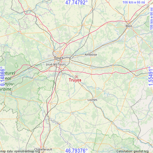
Truyes GPS coordinates[2]
47° 16' 22.764" North, 0° 51' 6.444" East
| Map corner | latitude | longitude |
|---|---|---|
| Upper-left | 47.74792°, | 0.14866° |
| Center: | 47.27299°, | 0.85179° |
| Lower-right: | 46.79376°, | 1.55491° |
| Map W x H: | 106.1×106.1 km | = 65.9×65.9mi |
| max Lat: | 51.07786° ⇑51.9% North |
| Truyes: | 47.27299° |
| min Lat: | ⇓48.1% South 41.3874° |
| min Long | Truyes | max Long |
| -5.08615° | 0.85179° | 9.52242° |
| W 29.9%⇐ | ⇒70.1% E |
Elevation
Elevation of Truyes is 76 m = 249 ft, and this is 117.7 m = 386 ft below average elevation for this country.
| Max E: |
2333 m = 7654 ft | 71% |
| Avg. | 193.7 m = 635 ft | |
| Truyes | 76 m = 249 ft | |
Min E: |
-1 m = -3 ft | 29% |
See also: France elevation on elevation.city.
Geographical zone
Truyes is located in North temperate zone (between Tropic of Cancer and the Arctic Circle). Distance of this North polar circle is 2144.9 km =1332.8 mi to North.| Distance of | km | miles | from Truyes |
|---|---|---|---|
| North Pole | 4750.8 | 2952 | to North |
| Arctic Circle | 2144.9 | 1332.8 | to North |
| Tropic Cancer | 2650.3 | 1646.8 | to South |
| Equator | 5256.3 | 3266.1 | to South |


Nearby cities:
15 places around Truyes: (largest is in red/bold)
• Athée-sur-Cher
7.2 km =4.5 mi,  42°
42°
• Azay-sur-Cher
8.5 km =5.3 mi,  356°
356°
• Bléré
12.2 km =7.6 mi,  60°
60°
• Cormery
1.3 km =0.8 mi,  245°
245°
• Courçay
2.9 km =1.8 mi,  141°
141°
• Dierre
11.3 km =7 mi, 44°
• Esvres
5.2 km =3.2 mi,  285°
285°
• Larçay
11.7 km =7.3 mi,  332°
332°
• Montbazon
11.5 km =7.1 mi,  275°
275°
• Reignac-sur-Indre
7.1 km =4.4 mi, 136°
• Saint-Branchs
7.9 km =4.9 mi,  229°
229°
• Saint-Martin-le-Beau
10.2 km =6.3 mi,  25°
25°
• Tauxigny
6.8 km =4.2 mi,  190°
190°
• Veigné
8.5 km =5.3 mi, 279°
• Véretz
10 km =6.2 mi,  339°
339°
Sources, notices
• [Note1] Compared only with cities in France existing in our database
• [Src1] Map data: © OpenStreetMap contributors (CC-BY-SA)
• [Src2] Other city data from geonames.org with taken over terms of usage.
• [Src3] Geographical zone / Annual Mean Temperature by Robert A. Rohde @ Wikipedia
