Vaumas geodata
Vaumas (Auvergne-Rhône-Alpes) is a populated place; located in France in Europe/Paris (GMT+2) time zone. With population of 544 people, there are 14318 cities with bigger population in this country. Compared to other cities in France, 60.6% of cities are located further ↑North; 65.2% of cities are located further ←West and 72.5% of cities have lower elevation than Vaumas. Note1
Administrative division(s):
- Level 1: Auvergne-Rhône-Alpes
- Level 2: Département de l'Allier
- Level 3: Arrondissement de Moulins
- Level 4: Vaumas


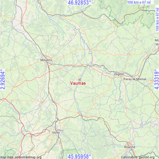
Vaumas GPS coordinates[2]
46° 26' 46.356" North, 3° 37' 48.252" East
| Map corner | latitude | longitude |
|---|---|---|
| Upper-left | 46.92853°, | 2.92694° |
| Center: | 46.44621°, | 3.63007° |
| Lower-right: | 45.95958°, | 4.33319° |
| Map W x H: | 107.7×107.7 km | = 66.9×66.9mi |
| max Lat: | 51.07786° ⇑60.6% North |
| Vaumas: | 46.44621° |
| min Lat: | ⇓39.4% South 41.3874° |
| min Long | Vaumas | max Long |
| -5.08615° | 3.63007° | 9.52242° |
| W 65.2%⇐ | ⇒34.8% E |
Elevation
Elevation of Vaumas is 233 m = 764 ft, and this is 39.3 m = 129 ft above average elevation for this country.
| Max E: |
2333 m = 7654 ft | 27.5% |
| Vaumas | 233 m 764 ft | |
| Avg. | 193.7 m = 635 ft | |
Min E: |
-1 m = -3 ft | 72.5% |
See also: France elevation on elevation.city.
Geographical zone
Vaumas is located in North temperate zone (between Tropic of Cancer and the Arctic Circle). Distance of this North polar circle is 2236.8 km =1389.9 mi to North.| Distance of | km | miles | from Vaumas |
|---|---|---|---|
| North Pole | 4842.7 | 3009.1 | to North |
| Arctic Circle | 2236.8 | 1389.9 | to North |
| Tropic Cancer | 2558.4 | 1589.7 | to South |
| Equator | 5164.3 | 3208.9 | to South |


Nearby cities:
15 places around Vaumas: (largest is in red/bold)
• Beaulon
17.6 km =10.9 mi,  10°
10°
• Diou
13.1 km =8.1 mi,  41°
41°
• Dompierre-sur-Besbre
9.3 km =5.8 mi,  24°
24°
• Gilly-sur-Loire
15.4 km =9.6 mi,  48°
48°
• Jaligny-sur-Besbre
7.9 km =4.9 mi,  207°
207°
• Le Donjon
16.4 km =10.2 mi,  130°
130°
• Lusigny
19 km =11.8 mi,  326°
326°
• Montbeugny
14.2 km =8.8 mi,  310°
310°
• Montoldre
18.8 km =11.7 mi,  228°
228°
• Neuilly-le-Réal
15.3 km =9.5 mi,  277°
277°
• Pierrefitte-sur-Loire
15.7 km =9.8 mi,  64°
64°
• Saint-Léon
6.5 km =4 mi,  138°
138°
• Saligny-sur-Roudon
9.5 km =5.9 mi,  75°
75°
• Thiel-sur-Acolin
9.3 km =5.8 mi,  336°
336°
• Treteau
11.9 km =7.4 mi,  222°
222°
Sources, notices
• [Note1] Compared only with cities in France existing in our database
• [Src1] Map data: © OpenStreetMap contributors (CC-BY-SA)
• [Src2] Other city data from geonames.org with taken over terms of usage.
• [Src3] Geographical zone / Annual Mean Temperature by Robert A. Rohde @ Wikipedia
