Montbeugny geodata
Montbeugny (Auvergne-Rhône-Alpes) is a populated place; located in France in Europe/Paris (GMT+2) time zone. With population of 604 people, there are 13253 cities with bigger population in this country. Compared to other cities in France, 59.9% of cities are located further ↑North; 64.1% of cities are located further ←West and 77.5% of cities have lower elevation than Montbeugny. Note1
Administrative division(s):
- Level 1: Auvergne-Rhône-Alpes
- Level 2: Département de l'Allier
- Level 3: Arrondissement de Moulins
- Level 4: Montbeugny


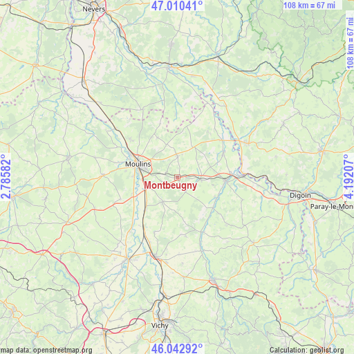
Montbeugny GPS coordinates[2]
46° 31' 43.752" North, 3° 29' 20.22" East
| Map corner | latitude | longitude |
|---|---|---|
| Upper-left | 47.01041°, | 2.78582° |
| Center: | 46.52882°, | 3.48895° |
| Lower-right: | 46.04292°, | 4.19207° |
| Map W x H: | 107.6×107.6 km | = 66.9×66.9mi |
| max Lat: | 51.07786° ⇑59.9% North |
| Montbeugny: | 46.52882° |
| min Lat: | ⇓40.1% South 41.3874° |
| min Long | Montbeugny | max Long |
| -5.08615° | 3.48895° | 9.52242° |
| W 64.1%⇐ | ⇒35.9% E |
Elevation
Elevation of Montbeugny is 268 m = 879 ft, and this is 74.3 m = 244 ft above average elevation for this country.
| Max E: |
2333 m = 7654 ft | 22.5% |
| Montbeugny | 268 m 879 ft | |
| Avg. | 193.7 m = 635 ft | |
Min E: |
-1 m = -3 ft | 77.5% |
See also: France elevation on elevation.city.
Geographical zone
Montbeugny is located in North temperate zone (between Tropic of Cancer and the Arctic Circle). Distance of this North polar circle is 2227.7 km =1384.2 mi to North.| Distance of | km | miles | from Montbeugny |
|---|---|---|---|
| North Pole | 4833.5 | 3003.4 | to North |
| Arctic Circle | 2227.7 | 1384.2 | to North |
| Tropic Cancer | 2567.6 | 1595.4 | to South |
| Equator | 5173.5 | 3214.7 | to South |


Nearby cities:
15 places around Montbeugny: (largest is in red/bold)
• Avermes
15.4 km =9.6 mi,  295°
295°
• Beaulon
16.2 km =10.1 mi,  60°
60°
• Bessay-sur-Allier
13.7 km =8.5 mi,  225°
225°
• Bressolles
13.2 km =8.2 mi,  270°
270°
• Chemilly
14.1 km =8.8 mi,  251°
251°
• Chevagnes
10.3 km =6.4 mi,  27°
27°
• Dompierre-sur-Besbre
14.7 km =9.1 mi,  92°
92°
• Lusigny
6.6 km =4.1 mi,  1°
1°
• Moulins
12.6 km =7.8 mi,  288°
288°
• Neuilly-le-Réal
8.4 km =5.2 mi,  211°
211°
• Neuvy
15.6 km =9.7 mi,  283°
283°
• Thiel-sur-Acolin
7.1 km =4.4 mi, 94°
• Toulon-sur-Allier
9.9 km =6.2 mi,  263°
263°
• Vaumas
14.2 km =8.8 mi,  130°
130°
• Yzeure
11.1 km =6.9 mi, 291°
Sources, notices
• [Note1] Compared only with cities in France existing in our database
• [Src1] Map data: © OpenStreetMap contributors (CC-BY-SA)
• [Src2] Other city data from geonames.org with taken over terms of usage.
• [Src3] Geographical zone / Annual Mean Temperature by Robert A. Rohde @ Wikipedia
