Marsais geodata
Marsais (Nouvelle-Aquitaine) is a populated place; located in France in Europe/Paris (GMT+2) time zone. With population of 839 people, there are 10196 cities with bigger population in this country. Compared to other cities in France, 64.7% of cities are located further ↑North; 84.5% of cities are located further →East and 85.9% of cities have higher elevation than Marsais. Note1
Administrative division(s):
- Level 1: Nouvelle-Aquitaine
- Level 2: Charente-Maritime
- Level 3: Arrondissement de Rochefort
- Level 4: Marsais


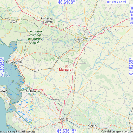
Marsais GPS coordinates[2]
46° 7' 32.268" North, 0° 36' 1.584" West
| Map corner | latitude | longitude |
|---|---|---|
| Upper-left | 46.6108°, | -1.30356° |
| Center: | 46.12563°, | -0.60044° |
| Lower-right: | 45.63615°, | 0.10269° |
| Map W x H: | 108.4×108.4 km | = 67.4×67.4mi |
| max Lat: | 51.07786° ⇑64.7% North |
| Marsais: | 46.12563° |
| min Lat: | ⇓35.3% South 41.3874° |
| min Long | Marsais | max Long |
| -5.08615° | -0.60044° | 9.52242° |
| W 15.5%⇐ | ⇒84.5% E |
Elevation
Elevation of Marsais is 40 m = 131 ft, and this is 153.7 m = 504 ft below average elevation for this country.
| Max E: |
2333 m = 7654 ft | 85.9% |
| Avg. | 193.7 m = 635 ft | |
| Marsais | 40 m = 131 ft | |
Min E: |
-1 m = -3 ft | 14.1% |
See also: France elevation on elevation.city.
Geographical zone
Marsais is located in North temperate zone (between Tropic of Cancer and the Arctic Circle). Distance of this North polar circle is 2272.5 km =1412.1 mi to North.| Distance of | km | miles | from Marsais |
|---|---|---|---|
| North Pole | 4878.4 | 3031.3 | to North |
| Arctic Circle | 2272.5 | 1412.1 | to North |
| Tropic Cancer | 2522.8 | 1567.6 | to South |
| Equator | 5128.7 | 3186.8 | to South |


Nearby cities:
15 places around Marsais: (largest is in red/bold)
• Beauvoir-sur-Niort
11.6 km =7.2 mi,  57°
57°
• Bernay-Saint-Martin
6.7 km =4.2 mi,  190°
190°
• Cramchaban
13.5 km =8.4 mi,  318°
318°
• La Foye-Monjault
8.3 km =5.2 mi,  35°
35°
• Loulay
11.3 km =7 mi,  141°
141°
• Mauzé-sur-le-Mignon
9.4 km =5.8 mi,  326°
326°
• Prissé-la-Charrière
8.2 km =5.1 mi,  70°
70°
• Saint-Georges-du-Bois
10.4 km =6.5 mi,  279°
279°
• Saint-Mard
9.6 km =6 mi,  242°
242°
• Saint-Saturnin-du-Bois
5.6 km =3.5 mi,  285°
285°
• Surgères
11.8 km =7.3 mi,  260°
260°
• Usseau
5.6 km =3.5 mi,  16°
16°
• Vallans
10.8 km =6.7 mi, 20°
• Villeneuve-la-Comtesse
8 km =5 mi,  112°
112°
• Épannes
11.7 km =7.3 mi,  6°
6°
Sources, notices
• [Note1] Compared only with cities in France existing in our database
• [Src1] Map data: © OpenStreetMap contributors (CC-BY-SA)
• [Src2] Other city data from geonames.org with taken over terms of usage.
• [Src3] Geographical zone / Annual Mean Temperature by Robert A. Rohde @ Wikipedia
