Claret geodata
Claret (Occitanie) is a populated place; located in France in Europe/Paris (GMT+2) time zone. With population of 1,324 people, there are 6924 cities with bigger population in this country. Compared to other cities in France, 88.5% of cities are located further ↑North; 67% of cities are located further ←West and 59.8% of cities have lower elevation than Claret. Note1
Administrative division(s):
- Level 1: Occitanie
- Level 2: Département de l'Hérault
- Level 3: Arrondissement de Lodève
- Level 4: Claret


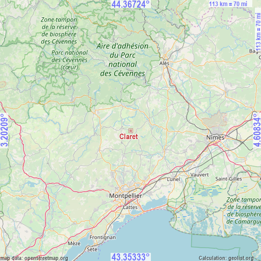
Claret GPS coordinates[2]
43° 51' 44.784" North, 3° 54' 18.792" East
| Map corner | latitude | longitude |
|---|---|---|
| Upper-left | 44.36724°, | 3.20209° |
| Center: | 43.86244°, | 3.90522° |
| Lower-right: | 43.35333°, | 4.60834° |
| Map W x H: | 112.7×112.7 km | = 70×70mi |
| max Lat: | 51.07786° ⇑88.5% North |
| Claret: | 43.86244° |
| min Lat: | ⇓11.5% South 41.3874° |
| min Long | Claret | max Long |
| -5.08615° | 3.90522° | 9.52242° |
| W 67%⇐ | ⇒33% E |
Elevation
Elevation of Claret is 169 m = 554 ft, and this is 24.7 m = 81 ft below average elevation for this country.
| Max E: |
2333 m = 7654 ft | 40.2% |
| Avg. | 193.7 m = 635 ft | |
| Claret | 169 m = 554 ft | |
Min E: |
-1 m = -3 ft | 59.8% |
See also: France elevation on elevation.city.
Geographical zone
Claret is located in North temperate zone (between Tropic of Cancer and the Arctic Circle). Distance of this Northern Tropic circle is 2271.1 km =1411.2 mi to South.| Distance of | km | miles | from Claret |
|---|---|---|---|
| North Pole | 5130 | 3187.6 | to North |
| Arctic Circle | 2524.1 | 1568.4 | to North |
| Tropic Cancer | 2271.1 | 1411.2 | to South |
| Equator | 4877 | 3030.4 | to South |


Nearby cities:
15 places around Claret: (largest is in red/bold)
• Corconne
2.9 km =1.8 mi,  68°
68°
• Durfort-et-Saint-Martin-de-Sossenac
14.7 km =9.1 mi,  15°
15°
• Galargues
13.8 km =8.6 mi,  137°
137°
• Monoblet
15.4 km =9.6 mi,  354°
354°
• Montaud
12.9 km =8 mi,  161°
161°
• Pompignan
5.3 km =3.3 mi,  311°
311°
• Quissac
9.4 km =5.8 mi,  53°
53°
• Saint-Bauzille-de-Montmel
11 km =6.8 mi, 158°
• Saint-Bauzille-de-Putois
14 km =8.7 mi,  284°
284°
• Saint-Hippolyte-du-Fort
11.9 km =7.4 mi,  340°
340°
• Saint-Jean-de-Cornies
15.2 km =9.4 mi,  149°
149°
• Saint-Mathieu-de-Tréviers
11.2 km =7 mi,  199°
199°
• Sainte-Croix-de-Quintillargues
10.1 km =6.3 mi,  178°
178°
• Sauve
9.5 km =5.9 mi, 21°
• Valflaunès
7.4 km =4.6 mi, 200°
Sources, notices
• [Note1] Compared only with cities in France existing in our database
• [Src1] Map data: © OpenStreetMap contributors (CC-BY-SA)
• [Src2] Other city data from geonames.org with taken over terms of usage.
• [Src3] Geographical zone / Annual Mean Temperature by Robert A. Rohde @ Wikipedia
