Corconne geodata
Corconne (Occitanie) is a populated place; located in France in Europe/Paris (GMT+2) time zone. With population of 525 people, there are 14719 cities with bigger population in this country. Compared to other cities in France, 88.4% of cities are located further ↑North; 67.3% of cities are located further ←West and 54.5% of cities have lower elevation than Corconne. Note1
Administrative division(s):
- Level 1: Occitanie
- Level 2: Gard
- Level 3: Arrondissement du Vigan
- Level 4: Corconne


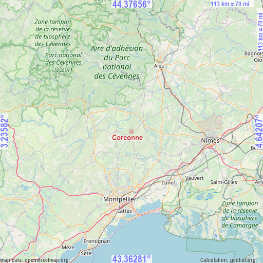
Corconne GPS coordinates[2]
43° 52' 18.624" North, 3° 56' 20.184" East
| Map corner | latitude | longitude |
|---|---|---|
| Upper-left | 44.37656°, | 3.23582° |
| Center: | 43.87184°, | 3.93894° |
| Lower-right: | 43.36281°, | 4.64207° |
| Map W x H: | 112.7×112.7 km | = 70×70mi |
| max Lat: | 51.07786° ⇑88.4% North |
| Corconne: | 43.87184° |
| min Lat: | ⇓11.6% South 41.3874° |
| min Long | Corconne | max Long |
| -5.08615° | 3.93894° | 9.52242° |
| W 67.3%⇐ | ⇒32.7% E |
Elevation
Elevation of Corconne is 148 m = 486 ft, and this is 45.7 m = 150 ft below average elevation for this country.
| Max E: |
2333 m = 7654 ft | 45.5% |
| Avg. | 193.7 m = 635 ft | |
| Corconne | 148 m = 486 ft | |
Min E: |
-1 m = -3 ft | 54.5% |
See also: France elevation on elevation.city.
Geographical zone
Corconne is located in North temperate zone (between Tropic of Cancer and the Arctic Circle). Distance of this Northern Tropic circle is 2272.2 km =1411.9 mi to South.| Distance of | km | miles | from Corconne |
|---|---|---|---|
| North Pole | 5129 | 3187 | to North |
| Arctic Circle | 2523.1 | 1567.8 | to North |
| Tropic Cancer | 2272.2 | 1411.9 | to South |
| Equator | 4878.1 | 3031.1 | to South |


Nearby cities:
15 places around Corconne: (largest is in red/bold)
• Claret
2.9 km =1.8 mi,  248°
248°
• Durfort-et-Saint-Martin-de-Sossenac
13.2 km =8.2 mi,  5°
5°
• Galargues
13 km =8.1 mi,  149°
149°
• Monoblet
14.9 km =9.3 mi,  343°
343°
• Montaud
13.4 km =8.3 mi,  174°
174°
• Pompignan
7.1 km =4.4 mi,  290°
290°
• Quissac
6.7 km =4.2 mi,  46°
46°
• Saint-Bauzille-de-Montmel
11.3 km =7 mi, 173°
• Saint-Hippolyte-du-Fort
12.2 km =7.6 mi,  326°
326°
• Saint-Jean-de-Cornies
15 km =9.3 mi,  160°
160°
• Saint-Mathieu-de-Tréviers
13.2 km =8.2 mi,  209°
209°
• Sainte-Croix-de-Quintillargues
11.4 km =7.1 mi,  192°
192°
• Saussines
15.4 km =9.6 mi,  142°
142°
• Sauve
7.8 km =4.8 mi, 5°
• Valflaunès
9.6 km =6 mi, 213°
Sources, notices
• [Note1] Compared only with cities in France existing in our database
• [Src1] Map data: © OpenStreetMap contributors (CC-BY-SA)
• [Src2] Other city data from geonames.org with taken over terms of usage.
• [Src3] Geographical zone / Annual Mean Temperature by Robert A. Rohde @ Wikipedia
