Courçay geodata
Courçay (Centre) is a populated place; located in France in Europe/Paris (GMT+2) time zone. With population of 728 people, there are 11431 cities with bigger population in this country. Compared to other cities in France, 52.3% of cities are located further ↑North; 70% of cities are located further →East and 65.6% of cities have higher elevation than Courçay. Note1
Administrative division(s):
- Level 1: Centre
- Level 2: Département d'Indre-et-Loire
- Level 3: Arrondissement de Loches
- Level 4: Courçay


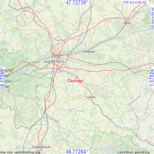
Courçay GPS coordinates[2]
47° 15' 8.1" North, 0° 52' 33.996" East
| Map corner | latitude | longitude |
|---|---|---|
| Upper-left | 47.72736°, | 0.17299° |
| Center: | 47.25225°, | 0.87611° |
| Lower-right: | 46.77284°, | 1.57924° |
| Map W x H: | 106.1×106.1 km | = 65.9×65.9mi |
| max Lat: | 51.07786° ⇑52.3% North |
| Courçay: | 47.25225° |
| min Lat: | ⇓47.7% South 41.3874° |
| min Long | Courçay | max Long |
| -5.08615° | 0.87611° | 9.52242° |
| W 30%⇐ | ⇒70% E |
Elevation
Elevation of Courçay is 88 m = 289 ft, and this is 105.7 m = 347 ft below average elevation for this country.
| Max E: |
2333 m = 7654 ft | 65.6% |
| Avg. | 193.7 m = 635 ft | |
| Courçay | 88 m = 289 ft | |
Min E: |
-1 m = -3 ft | 34.4% |
See also: France elevation on elevation.city.
Geographical zone
Courçay is located in North temperate zone (between Tropic of Cancer and the Arctic Circle). Distance of this North polar circle is 2147.2 km =1334.2 mi to North.| Distance of | km | miles | from Courçay |
|---|---|---|---|
| North Pole | 4753.1 | 2953.4 | to North |
| Arctic Circle | 2147.2 | 1334.2 | to North |
| Tropic Cancer | 2648 | 1645.4 | to South |
| Equator | 5254 | 3264.7 | to South |


Nearby cities:
15 places around Courçay: (largest is in red/bold)
• Athée-sur-Cher
8.2 km =5.1 mi,  21°
21°
• Azay-sur-Cher
11.1 km =6.9 mi,  348°
348°
• Bléré
12.1 km =7.5 mi,  46°
46°
• Chambourg-sur-Indre
10.5 km =6.5 mi,  138°
138°
• Cormery
3.5 km =2.2 mi,  300°
300°
• Dierre
12 km =7.5 mi,  30°
30°
• Dolus-le-Sec
9.8 km =6.1 mi,  172°
172°
• Esvres
7.7 km =4.8 mi, 298°
• Louans
12.3 km =7.6 mi,  232°
232°
• Reignac-sur-Indre
4.1 km =2.5 mi,  133°
133°
• Saint-Branchs
8.3 km =5.2 mi,  249°
249°
• Saint-Martin-le-Beau
11.8 km =7.3 mi,  12°
12°
• Tauxigny
5.3 km =3.3 mi,  215°
215°
• Truyes
2.9 km =1.8 mi,  321°
321°
• Veigné
10.9 km =6.8 mi,  289°
289°
Sources, notices
• [Note1] Compared only with cities in France existing in our database
• [Src1] Map data: © OpenStreetMap contributors (CC-BY-SA)
• [Src2] Other city data from geonames.org with taken over terms of usage.
• [Src3] Geographical zone / Annual Mean Temperature by Robert A. Rohde @ Wikipedia
