Trumilly geodata
Trumilly (Hauts-de-France) is a populated place; located in France in Europe/Paris (GMT+2) time zone. With population of 517 people, there are 14885 cities with bigger population in this country. Compared to other cities in France, 85% of cities are located further ↓South; 54.9% of cities are located further ←West and 55.9% of cities have higher elevation than Trumilly. Note1
Administrative division(s):
- Level 1: Hauts-de-France
- Level 2: Département de l'Oise
- Level 3: Arrondissement de Senlis
- Level 4: Trumilly


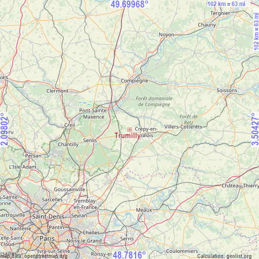
Trumilly GPS coordinates[2]
49° 14' 33.972" North, 2° 48' 4.104" East
| Map corner | latitude | longitude |
|---|---|---|
| Upper-left | 49.69968°, | 2.09802° |
| Center: | 49.24277°, | 2.80114° |
| Lower-right: | 48.7816°, | 3.50427° |
| Map W x H: | 102.1×102.1 km | = 63.4×63.4mi |
| max Lat: | 51.07786° ⇑15% North |
| Trumilly: | 49.24277° |
| min Lat: | ⇓85% South 41.3874° |
| min Long | Trumilly | max Long |
| -5.08615° | 2.80114° | 9.52242° |
| W 54.9%⇐ | ⇒45.1% E |
Elevation
Elevation of Trumilly is 114 m = 374 ft, and this is 79.7 m = 261 ft below average elevation for this country.
| Max E: |
2333 m = 7654 ft | 55.9% |
| Avg. | 193.7 m = 635 ft | |
| Trumilly | 114 m = 374 ft | |
Min E: |
-1 m = -3 ft | 44.1% |
See also: France elevation on elevation.city.
Geographical zone
Trumilly is located in North temperate zone (between Tropic of Cancer and the Arctic Circle). Distance of this North polar circle is 1925.9 km =1196.7 mi to North.| Distance of | km | miles | from Trumilly |
|---|---|---|---|
| North Pole | 4531.8 | 2815.9 | to North |
| Arctic Circle | 1925.9 | 1196.7 | to North |
| Tropic Cancer | 2869.4 | 1783 | to South |
| Equator | 5475.3 | 3402.2 | to South |


Nearby cities:
15 places around Trumilly: (largest is in red/bold)
• Baron
9.3 km =5.8 mi,  213°
213°
• Béthisy-Saint-Martin
5.9 km =3.7 mi,  11°
11°
• Béthisy-Saint-Pierre
6.9 km =4.3 mi,  357°
357°
• Crépy-en-Valois
6.4 km =4 mi,  99°
99°
• Gilocourt
7.9 km =4.9 mi,  45°
45°
• Lévignen
9.6 km =6 mi,  119°
119°
• Néry
4.7 km =2.9 mi,  338°
338°
• Orrouy
6.7 km =4.2 mi,  37°
37°
• Péroy-les-Gombries
9.5 km =5.9 mi,  160°
160°
• Rully
5.4 km =3.4 mi,  260°
260°
• Saint-Sauveur
8.5 km =5.3 mi,  351°
351°
• Saint-Vaast-de-Longmont
8.2 km =5.1 mi,  325°
325°
• Saintines
7.7 km =4.8 mi, 340°
• Verberie
9.1 km =5.7 mi, 326°
• Villeneuve-sur-Verberie
8.8 km =5.5 mi,  293°
293°
Sources, notices
• [Note1] Compared only with cities in France existing in our database
• [Src1] Map data: © OpenStreetMap contributors (CC-BY-SA)
• [Src2] Other city data from geonames.org with taken over terms of usage.
• [Src3] Geographical zone / Annual Mean Temperature by Robert A. Rohde @ Wikipedia
