Villeneuve-sur-Verberie geodata
Villeneuve-sur-Verberie (Hauts-de-France) is a populated place; located in France in Europe/Paris (GMT+2) time zone. With population of 655 people, there are 12455 cities with bigger population in this country. Compared to other cities in France, 85.6% of cities are located further ↓South; 53.3% of cities are located further ←West and 54.1% of cities have higher elevation than Villeneuve-sur-Verberie. Note1
Administrative division(s):
- Level 1: Hauts-de-France
- Level 2: Département de l'Oise
- Level 3: Arrondissement de Senlis
- Level 4: Villeneuve-sur-Verberie
Current local time in Villeneuve-sur-Verberie:
04:58 AM, SaturdayDifference from your time zone: hours


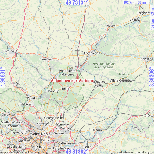
Villeneuve-sur-Verberie GPS coordinates[2]
49° 16' 28.92" North, 2° 41' 23.748" East
| Map corner | latitude | longitude |
|---|---|---|
| Upper-left | 49.73131°, | 1.98681° |
| Center: | 49.2747°, | 2.68993° |
| Lower-right: | 48.81382°, | 3.39306° |
| Map W x H: | 102×102 km | = 63.4×63.4mi |
| max Lat: | 51.07786° ⇑14.4% North |
| Villeneuve-sur-Verberie: | 49.2747° |
| min Lat: | ⇓85.6% South 41.3874° |
| min Long | Villeneuve-sur- | max Long |
| -5.08615° | 2.68993° | 9.52242° |
| W 53.3%⇐ | ⇒46.7% E |
Elevation
Elevation of Villeneuve-sur-Verberie is 119 m = 390 ft, and this is 74.7 m = 245 ft below average elevation for this country.
| Max E: |
2333 m = 7654 ft | 54.1% |
| Avg. | 193.7 m = 635 ft | |
| Villeneuve-sur-Verberie | 119 m = 390 ft | |
Min E: |
-1 m = -3 ft | 45.9% |
See also: France elevation on elevation.city.
Geographical zone
Villeneuve-sur-Verberie is located in North temperate zone (between Tropic of Cancer and the Arctic Circle). Distance of this North polar circle is 1922.3 km =1194.5 mi to North.| Distance of | km | miles | from Villeneuve-sur-Verberie |
|---|---|---|---|
| North Pole | 4528.2 | 2813.7 | to North |
| Arctic Circle | 1922.3 | 1194.5 | to North |
| Tropic Cancer | 2872.9 | 1785.1 | to South |
| Equator | 5478.8 | 3404.4 | to South |


Nearby cities:
15 places around Villeneuve-sur-Verberie: (largest is in red/bold)
• Barbery
6 km =3.7 mi,  195°
195°
• Chamant
8.3 km =5.2 mi,  222°
222°
• Chevrières
8 km =5 mi,  355°
355°
• Fleurines
7.9 km =4.9 mi,  257°
257°
• Les Ageux
8 km =5 mi,  305°
305°
• Néry
6.4 km =4 mi,  82°
82°
• Pont-Sainte-Maxence
6.9 km =4.3 mi,  295°
295°
• Pontpoint
4 km =2.5 mi, 314°
• Rully
5.2 km =3.2 mi,  148°
148°
• Saint-Pierre
3.8 km =2.4 mi,  320°
320°
• Saint-Sauveur
8.3 km =5.2 mi,  54°
54°
• Saint-Vaast-de-Longmont
4.7 km =2.9 mi, 47°
• Saintines
6.6 km =4.1 mi,  55°
55°
• Verberie
5.1 km =3.2 mi,  37°
37°
• Villers-Saint-Frambourg
4.2 km =2.6 mi,  238°
238°
Sources, notices
• [Note1] Compared only with cities in France existing in our database
• [Src1] Map data: © OpenStreetMap contributors (CC-BY-SA)
• [Src2] Other city data from geonames.org with taken over terms of usage.
• [Src3] Geographical zone / Annual Mean Temperature by Robert A. Rohde @ Wikipedia
