Néry geodata
Néry (Hauts-de-France) is a populated place; located in France in Europe/Paris (GMT+2) time zone. With population of 731 people, there are 11400 cities with bigger population in this country. Compared to other cities in France, 85.7% of cities are located further ↓South; 54.6% of cities are located further ←West and 60.4% of cities have higher elevation than Néry. Note1
Administrative division(s):
- Level 1: Hauts-de-France
- Level 2: Département de l'Oise
- Level 3: Arrondissement de Senlis
- Level 4: Néry


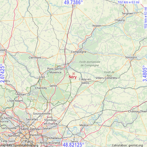
Néry GPS coordinates[2]
49° 16' 55.416" North, 2° 46' 38.532" East
| Map corner | latitude | longitude |
|---|---|---|
| Upper-left | 49.7386°, | 2.07425° |
| Center: | 49.28206°, | 2.77737° |
| Lower-right: | 48.82125°, | 3.4805° |
| Map W x H: | 102×102 km | = 63.4×63.4mi |
| max Lat: | 51.07786° ⇑14.3% North |
| Néry: | 49.28206° |
| min Lat: | ⇓85.7% South 41.3874° |
| min Long | Néry | max Long |
| -5.08615° | 2.77737° | 9.52242° |
| W 54.6%⇐ | ⇒45.4% E |
Elevation
Elevation of Néry is 101 m = 331 ft, and this is 92.7 m = 304 ft below average elevation for this country.
| Max E: |
2333 m = 7654 ft | 60.4% |
| Avg. | 193.7 m = 635 ft | |
| Néry | 101 m = 331 ft | |
Min E: |
-1 m = -3 ft | 39.6% |
See also: France elevation on elevation.city.
Geographical zone
Néry is located in North temperate zone (between Tropic of Cancer and the Arctic Circle). Distance of this North polar circle is 1921.5 km =1194 mi to North.| Distance of | km | miles | from Néry |
|---|---|---|---|
| North Pole | 4527.4 | 2813.2 | to North |
| Arctic Circle | 1921.5 | 1194 | to North |
| Tropic Cancer | 2873.7 | 1785.6 | to South |
| Equator | 5479.7 | 3404.9 | to South |


Nearby cities:
15 places around Néry: (largest is in red/bold)
• Béthisy-Saint-Martin
3.2 km =2 mi,  64°
64°
• Béthisy-Saint-Pierre
2.9 km =1.8 mi,  28°
28°
• Gilocourt
7.4 km =4.6 mi,  81°
81°
• Lacroix-Saint-Ouen
8.4 km =5.2 mi,  5°
5°
• Orrouy
5.9 km =3.7 mi, 80°
• Pontpoint
9.4 km =5.8 mi,  282°
282°
• Rivecourt
7.9 km =4.9 mi,  337°
337°
• Rully
6.4 km =4 mi,  214°
214°
• Saint-Pierre
9 km =5.6 mi, 283°
• Saint-Sauveur
4.1 km =2.5 mi, 5°
• Saint-Vaast-de-Longmont
3.7 km =2.3 mi,  308°
308°
• Saintines
3 km =1.9 mi, 342°
• Trumilly
4.7 km =2.9 mi,  158°
158°
• Verberie
4.6 km =2.9 mi, 314°
• Villeneuve-sur-Verberie
6.4 km =4 mi,  262°
262°
Sources, notices
• [Note1] Compared only with cities in France existing in our database
• [Src1] Map data: © OpenStreetMap contributors (CC-BY-SA)
• [Src2] Other city data from geonames.org with taken over terms of usage.
• [Src3] Geographical zone / Annual Mean Temperature by Robert A. Rohde @ Wikipedia
