Trélazé geodata
Trélazé (Pays de la Loire) is a populated place; located in France in Europe/Paris (GMT+2) time zone. With population of 11,740 people, there are 818 cities with bigger population in this country. Compared to other cities in France, 50.5% of cities are located further ↓South; 82.9% of cities are located further →East and 93.1% of cities have higher elevation than Trélazé. Note1
Administrative division(s):
- Level 1: Pays de la Loire
- Level 2: Département de Maine-et-Loire
- Level 3: Angers
- Level 4: Trélazé


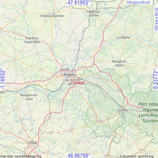
Trélazé GPS coordinates[2]
47° 26' 44.34" North, 0° 27' 55.44" West
| Map corner | latitude | longitude |
|---|---|---|
| Upper-left | 47.91902°, | -1.16852° |
| Center: | 47.44565°, | -0.4654° |
| Lower-right: | 46.96798°, | 0.23772° |
| Map W x H: | 105.7×105.7 km | = 65.7×65.7mi |
| max Lat: | 51.07786° ⇑49.5% North |
| Trélazé: | 47.44565° |
| min Lat: | ⇓50.5% South 41.3874° |
| min Long | Trélazé | max Long |
| -5.08615° | -0.4654° | 9.52242° |
| W 17.1%⇐ | ⇒82.9% E |
Elevation
Elevation of Trélazé is 22 m = 72 ft, and this is 171.7 m = 563 ft below average elevation for this country.
| Max E: |
2333 m = 7654 ft | 93.1% |
| Avg. | 193.7 m = 635 ft | |
| Trélazé | 22 m = 72 ft | |
Min E: |
-1 m = -3 ft | 6.9% |
See also: France elevation on elevation.city.
Geographical zone
Trélazé is located in North temperate zone (between Tropic of Cancer and the Arctic Circle). Distance of this North polar circle is 2125.7 km =1320.8 mi to North.| Distance of | km | miles | from Trélazé |
|---|---|---|---|
| North Pole | 4731.6 | 2940.1 | to North |
| Arctic Circle | 2125.7 | 1320.8 | to North |
| Tropic Cancer | 2669.5 | 1658.7 | to South |
| Equator | 5275.5 | 3278 | to South |


Nearby cities:
15 places around Trélazé: (largest is in red/bold)
• Andard
5.2 km =3.2 mi,  76°
76°
• Angers
6.9 km =4.3 mi,  296°
296°
• Blaison-Gohier
8.4 km =5.2 mi,  127°
127°
• Corné
9.1 km =5.7 mi,  72°
72°
• Juigné-sur-Loire
4.3 km =2.7 mi,  191°
191°
• La Bohalle
5.8 km =3.6 mi,  118°
118°
• La Daguenière
3.9 km =2.4 mi,  138°
138°
• Le Plessis-Grammoire
6.5 km =4 mi,  24°
24°
• Les Ponts-de-Cé
5.1 km =3.2 mi,  240°
240°
• Mûrs-Erigné
8.1 km =5 mi,  231°
231°
• Pellouailles-les-Vignes
8.7 km =5.4 mi,  12°
12°
• Saint-Jean-des-Mauvrets
5.4 km =3.4 mi,  166°
166°
• Saint-Saturnin-sur-Loire
6.1 km =3.8 mi,  158°
158°
• Sainte-Gemmes-sur-Loire
7.3 km =4.5 mi,  249°
249°
• Sarrigné
8.8 km =5.5 mi,  44°
44°
Sources, notices
• [Note1] Compared only with cities in France existing in our database
• [Src1] Map data: © OpenStreetMap contributors (CC-BY-SA)
• [Src2] Other city data from geonames.org with taken over terms of usage.
• [Src3] Geographical zone / Annual Mean Temperature by Robert A. Rohde @ Wikipedia
