Angers geodata
Angers (Pays de la Loire) is a seat of a second-order administrative division; located in France in Europe/Paris (GMT+2) time zone. With population of 168,279 people, there are 16 cities with bigger population in this country. Compared to other cities in France, 50.8% of cities are located further ↓South; 83.9% of cities are located further →East and 86.2% of cities have higher elevation than Angers. Note1
Administrative division(s):
- Level 1: Pays de la Loire
- Level 2: Département de Maine-et-Loire
- Level 3: Angers
- Level 4: Angers


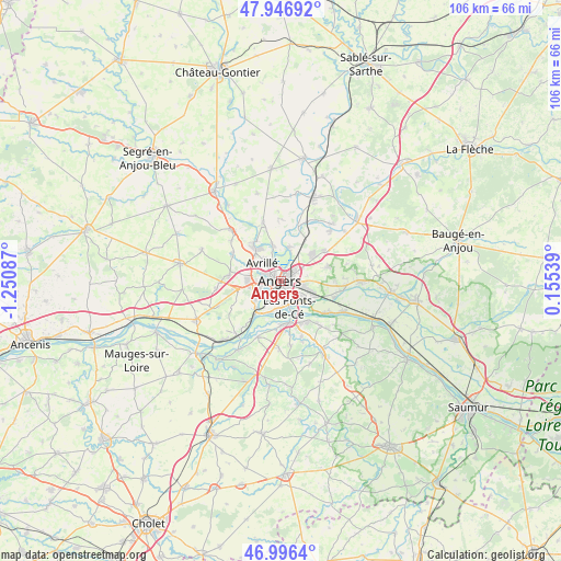
Angers GPS coordinates[2]
47° 28' 25.716" North, 0° 32' 51.864" West
| Map corner | latitude | longitude |
|---|---|---|
| Upper-left | 47.94692°, | -1.25087° |
| Center: | 47.47381°, | -0.54774° |
| Lower-right: | 46.9964°, | 0.15539° |
| Map W x H: | 105.7×105.7 km | = 65.7×65.7mi |
| max Lat: | 51.07786° ⇑49.2% North |
| Angers: | 47.47381° |
| min Lat: | ⇓50.8% South 41.3874° |
| min Long | Angers | max Long |
| -5.08615° | -0.54774° | 9.52242° |
| W 16.1%⇐ | ⇒83.9% E |
Elevation
Elevation of Angers is 39 m = 128 ft, and this is 154.7 m = 508 ft below average elevation for this country.
| Max E: |
2333 m = 7654 ft | 86.2% |
| Avg. | 193.7 m = 635 ft | |
| Angers | 39 m = 128 ft | |
Min E: |
-1 m = -3 ft | 13.8% |
See also: Angers elevation on elevation.city.
Geographical zone
Angers is located in North temperate zone (between Tropic of Cancer and the Arctic Circle). Distance of this North polar circle is 2122.6 km =1318.9 mi to North.| Distance of | km | miles | from Angers |
|---|---|---|---|
| North Pole | 4728.5 | 2938.2 | to North |
| Arctic Circle | 2122.6 | 1318.9 | to North |
| Tropic Cancer | 2672.7 | 1660.7 | to South |
| Equator | 5278.6 | 3280 | to South |


Nearby cities:
15 places around Angers: (largest is in red/bold)
• Avrillé
4 km =2.5 mi,  317°
317°
• Beaucouzé
6.2 km =3.9 mi,  270°
270°
• Bouchemaine
7.3 km =4.5 mi,  218°
218°
• Briollay
10.6 km =6.6 mi,  16°
16°
• Cantenay-Épinard
7 km =4.3 mi,  346°
346°
• Juigné-sur-Loire
9.1 km =5.7 mi,  144°
144°
• La Meignanne
10.3 km =6.4 mi,  297°
297°
• Le Plessis-Grammoire
9.3 km =5.8 mi,  72°
72°
• Les Ponts-de-Cé
5.9 km =3.7 mi,  162°
162°
• Mûrs-Erigné
8.2 km =5.1 mi,  181°
181°
• Pellouailles-les-Vignes
9.7 km =6 mi,  56°
56°
• Saint-Lambert-la-Potherie
9.8 km =6.1 mi,  275°
275°
• Sainte-Gemmes-sur-Loire
5.7 km =3.5 mi,  186°
186°
• Trélazé
6.9 km =4.3 mi,  116°
116°
• Écouflant
6.5 km =4 mi,  13°
13°
Sources, notices
• [Note1] Compared only with cities in France existing in our database
• [Src1] Map data: © OpenStreetMap contributors (CC-BY-SA)
• [Src2] Other city data from geonames.org with taken over terms of usage.
• [Src3] Geographical zone / Annual Mean Temperature by Robert A. Rohde @ Wikipedia
