Blaison-Gohier geodata
Blaison-Gohier (Pays de la Loire) is a populated place; located in France in Europe/Paris (GMT+2) time zone. With population of 1,014 people, there are 8739 cities with bigger population in this country. Compared to other cities in France, 50.1% of cities are located further ↑North; 81.8% of cities are located further →East and 89.9% of cities have higher elevation than Blaison-Gohier. Note1
Administrative division(s):
- Level 1: Pays de la Loire
- Level 2: Département de Maine-et-Loire
- Level 3: Angers
- Level 4: Blaison-Saint-Sulpice


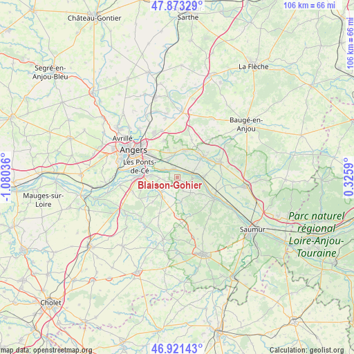
Blaison-Gohier GPS coordinates[2]
47° 23' 58.236" North, 0° 22' 38.028" West
| Map corner | latitude | longitude |
|---|---|---|
| Upper-left | 47.87329°, | -1.08036° |
| Center: | 47.39951°, | -0.37723° |
| Lower-right: | 46.92143°, | 0.3259° |
| Map W x H: | 105.8×105.8 km | = 65.7×65.7mi |
| max Lat: | 51.07786° ⇑50.1% North |
| Blaison-Gohier: | 47.39951° |
| min Lat: | ⇓49.9% South 41.3874° |
| min Long | Blaison-Gohier | max Long |
| -5.08615° | -0.37723° | 9.52242° |
| W 18.2%⇐ | ⇒81.8% E |
Elevation
Elevation of Blaison-Gohier is 30 m = 98 ft, and this is 163.7 m = 537 ft below average elevation for this country.
| Max E: |
2333 m = 7654 ft | 89.9% |
| Avg. | 193.7 m = 635 ft | |
| Blaison-Gohier | 30 m = 98 ft | |
Min E: |
-1 m = -3 ft | 10.1% |
See also: France elevation on elevation.city.
Geographical zone
Blaison-Gohier is located in North temperate zone (between Tropic of Cancer and the Arctic Circle). Distance of this North polar circle is 2130.8 km =1324 mi to North.| Distance of | km | miles | from Blaison-Gohier |
|---|---|---|---|
| North Pole | 4736.7 | 2943.2 | to North |
| Arctic Circle | 2130.8 | 1324 | to North |
| Tropic Cancer | 2664.4 | 1655.6 | to South |
| Equator | 5270.3 | 3274.8 | to South |


Nearby cities:
15 places around Blaison-Gohier: (largest is in red/bold)
• Andard
6.5 km =4 mi,  346°
346°
• Brissac-Quincé
7.3 km =4.5 mi,  228°
228°
• Charcé-Saint-Ellier-sur-Aubance
5.3 km =3.3 mi,  209°
209°
• Chemellier
6.7 km =4.2 mi,  167°
167°
• Corné
8.2 km =5.1 mi,  14°
14°
• Coutures
4.4 km =2.7 mi,  157°
157°
• Juigné-sur-Loire
7.5 km =4.7 mi,  276°
276°
• La Bohalle
2.8 km =1.7 mi,  327°
327°
• La Daguenière
4.6 km =2.9 mi,  298°
298°
• La Ménitré
8.3 km =5.2 mi,  89°
89°
• Saint-Jean-des-Mauvrets
5.4 km =3.4 mi,  268°
268°
• Saint-Mathurin-sur-Loire
4.9 km =3 mi,  67°
67°
• Saint-Rémy-la-Varenne
4.7 km =2.9 mi, 92°
• Saint-Saturnin-sur-Loire
4.4 km =2.7 mi,  262°
262°
• Trélazé
8.4 km =5.2 mi,  307°
307°
Sources, notices
• [Note1] Compared only with cities in France existing in our database
• [Src1] Map data: © OpenStreetMap contributors (CC-BY-SA)
• [Src2] Other city data from geonames.org with taken over terms of usage.
• [Src3] Geographical zone / Annual Mean Temperature by Robert A. Rohde @ Wikipedia
