Tréguier geodata
Tréguier (Brittany) is a populated place; located in France in Europe/Paris (GMT+2) time zone. With population of 3,011 people, there are 3241 cities with bigger population in this country. Compared to other cities in France, 75.1% of cities are located further ↓South; 97.8% of cities are located further →East and 80.6% of cities have higher elevation than Tréguier. Note1
Administrative division(s):
- Level 1: Brittany
- Level 2: Département des Côtes-d’Armor
- Level 3: Arrondissement de Lannion
- Level 4: Tréguier


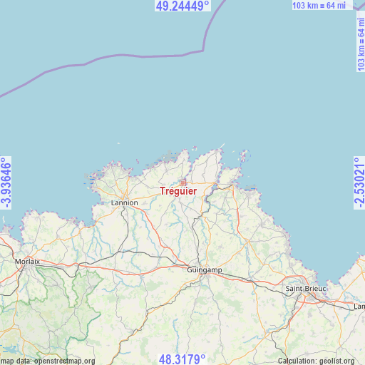
Tréguier GPS coordinates[2]
48° 46' 59.988" North, 3° 13' 59.988" West
| Map corner | latitude | longitude |
|---|---|---|
| Upper-left | 49.24449°, | -3.93646° |
| Center: | 48.78333°, | -3.23333° |
| Lower-right: | 48.3179°, | -2.53021° |
| Map W x H: | 103×103 km | = 64×64mi |
| max Lat: | 51.07786° ⇑24.9% North |
| Tréguier: | 48.78333° |
| min Lat: | ⇓75.1% South 41.3874° |
| min Long | Tréguier | max Long |
| -5.08615° | -3.23333° | 9.52242° |
| W 2.2%⇐ | ⇒97.8% E |
Elevation
Elevation of Tréguier is 53 m = 174 ft, and this is 140.7 m = 462 ft below average elevation for this country.
| Max E: |
2333 m = 7654 ft | 80.6% |
| Avg. | 193.7 m = 635 ft | |
| Tréguier | 53 m = 174 ft | |
Min E: |
-1 m = -3 ft | 19.4% |
See also: France elevation on elevation.city.
Geographical zone
Tréguier is located in North temperate zone (between Tropic of Cancer and the Arctic Circle). Distance of this North polar circle is 1977 km =1228.5 mi to North.| Distance of | km | miles | from Tréguier |
|---|---|---|---|
| North Pole | 4582.9 | 2847.7 | to North |
| Arctic Circle | 1977 | 1228.5 | to North |
| Tropic Cancer | 2818.3 | 1751.2 | to South |
| Equator | 5424.2 | 3370.4 | to South |


Nearby cities:
15 places around Tréguier: (largest is in red/bold)
• Camlez
5.2 km =3.2 mi,  263°
263°
• La Roche-Derrien
4.6 km =2.9 mi,  206°
206°
• Langoat
5.1 km =3.2 mi,  223°
223°
• Lézardrieux
9.3 km =5.8 mi,  88°
88°
• Minihy-Tréguier
0.7 km =0.4 mi,  153°
153°
• Penvénan
5.5 km =3.4 mi,  304°
304°
• Pleubian
9.6 km =6 mi,  46°
46°
• Pleudaniel
7.1 km =4.4 mi,  105°
105°
• Pleumeur-Gautier
6 km =3.7 mi,  71°
71°
• Plougrescant
6.3 km =3.9 mi,  2°
2°
• Plouguiel
1.6 km =1 mi,  345°
345°
• Ploëzal
7.9 km =4.9 mi,  163°
163°
• Pommerit-Jaudy
5.9 km =3.7 mi,  186°
186°
• Trédarzec
2.4 km =1.5 mi,  83°
83°
• Trévou-Tréguignec
8.8 km =5.5 mi, 296°
Sources, notices
• [Note1] Compared only with cities in France existing in our database
• [Src1] Map data: © OpenStreetMap contributors (CC-BY-SA)
• [Src2] Other city data from geonames.org with taken over terms of usage.
• [Src3] Geographical zone / Annual Mean Temperature by Robert A. Rohde @ Wikipedia
