Toulouse geodata
Toulouse (Occitanie) is a seat of a first-order administrative division; located in France in Europe/Paris (GMT+2) time zone. With population of 433,055 people, there are 3 cities with bigger population in this country. Compared to other cities in France, 91.8% of cities are located further ↑North; 63.7% of cities are located further →East and 55% of cities have lower elevation than Toulouse. Note1
Administrative division(s):
- Level 1: Occitanie
- Level 2: Haute-Garonne
- Level 3: Arrondissement de Toulouse
- Level 4: Toulouse


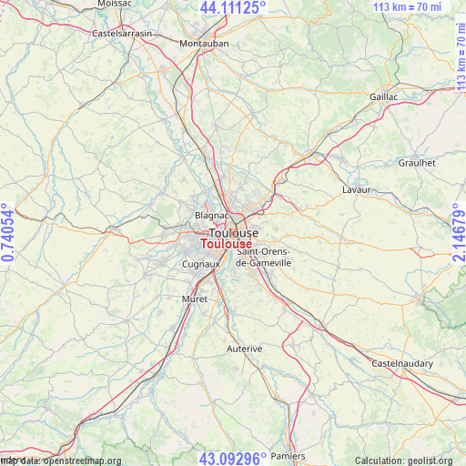
Toulouse GPS coordinates[2]
43° 36' 15.336" North, 1° 26' 37.212" East
| Map corner | latitude | longitude |
|---|---|---|
| Upper-left | 44.11125°, | 0.74054° |
| Center: | 43.60426°, | 1.44367° |
| Lower-right: | 43.09296°, | 2.14679° |
| Map W x H: | 113.2×113.2 km | = 70.3×70.3mi |
| max Lat: | 51.07786° ⇑91.8% North |
| Toulouse: | 43.60426° |
| min Lat: | ⇓8.2% South 41.3874° |
| min Long | Toulouse | max Long |
| -5.08615° | 1.44367° | 9.52242° |
| W 36.3%⇐ | ⇒63.7% E |
Elevation
Elevation of Toulouse is 150 m = 492 ft, and this is 43.7 m = 143 ft below average elevation for this country.
| Max E: |
2333 m = 7654 ft | 45% |
| Avg. | 193.7 m = 635 ft | |
| Toulouse | 150 m = 492 ft | |
Min E: |
-1 m = -3 ft | 55% |
See also: Toulouse elevation on elevation.city.
Geographical zone
Toulouse is located in North temperate zone (between Tropic of Cancer and the Arctic Circle). Distance of this Northern Tropic circle is 2242.4 km =1393.4 mi to South.| Distance of | km | miles | from Toulouse |
|---|---|---|---|
| North Pole | 5158.7 | 3205.5 | to North |
| Arctic Circle | 2552.8 | 1586.2 | to North |
| Tropic Cancer | 2242.4 | 1393.4 | to South |
| Equator | 4848.3 | 3012.6 | to South |


Nearby cities:
15 places around Toulouse: (largest is in red/bold)
• Aucamville
7.4 km =4.6 mi,  350°
350°
• Auzeville-Tolosane
9.1 km =5.7 mi,  159°
159°
• Balma
4.6 km =2.9 mi,  80°
80°
• Beauzelle
8.9 km =5.5 mi,  321°
321°
• Blagnac
5.1 km =3.2 mi,  308°
308°
• Colomiers
8.8 km =5.5 mi,  274°
274°
• Fonbeauzard
8.3 km =5.2 mi, 354°
• L'Union
7 km =4.3 mi,  26°
26°
• Launaguet
8.3 km =5.2 mi,  6°
6°
• Montrabé
7.9 km =4.9 mi,  55°
55°
• Pechbusque
8.4 km =5.2 mi,  173°
173°
• Pin-Balma
7.7 km =4.8 mi,  69°
69°
• Ramonville-Saint-Agne
6.9 km =4.3 mi, 158°
• Saint-Jean
8 km =5 mi, 33°
• Vieille-Toulouse
9 km =5.6 mi,  180°
180°
In other languages:
- In Spanish: Toulouse, Tolosa, Tolosa de Francia
- In Italian: Tolosa
- In Russian: Тулуза
- In Chinese: 圖盧茲
Sources, notices
• [Note1] Compared only with cities in France existing in our database
• [Src1] Map data: © OpenStreetMap contributors (CC-BY-SA)
• [Src2] Other city data from geonames.org with taken over terms of usage.
• [Src3] Geographical zone / Annual Mean Temperature by Robert A. Rohde @ Wikipedia
