Balma geodata
Balma (Occitanie) is a populated place; located in France in Europe/Paris (GMT+2) time zone. With population of 15,553 people, there are 620 cities with bigger population in this country. Compared to other cities in France, 91.7% of cities are located further ↑North; 63% of cities are located further →East and 57.6% of cities have lower elevation than Balma. Note1
Administrative division(s):
- Level 1: Occitanie
- Level 2: Haute-Garonne
- Level 3: Arrondissement de Toulouse
- Level 4: Balma


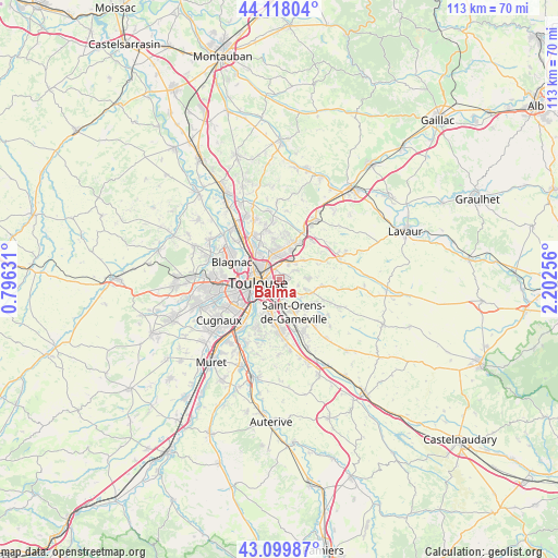
Balma GPS coordinates[2]
43° 36' 39.996" North, 1° 29' 57.984" East
| Map corner | latitude | longitude |
|---|---|---|
| Upper-left | 44.11804°, | 0.79631° |
| Center: | 43.61111°, | 1.49944° |
| Lower-right: | 43.09987°, | 2.20256° |
| Map W x H: | 113.2×113.2 km | = 70.3×70.3mi |
| max Lat: | 51.07786° ⇑91.7% North |
| Balma: | 43.61111° |
| min Lat: | ⇓8.3% South 41.3874° |
| min Long | Balma | max Long |
| -5.08615° | 1.49944° | 9.52242° |
| W 37%⇐ | ⇒63% E |
Elevation
Elevation of Balma is 160 m = 525 ft, and this is 33.7 m = 111 ft below average elevation for this country.
| Max E: |
2333 m = 7654 ft | 42.4% |
| Avg. | 193.7 m = 635 ft | |
| Balma | 160 m = 525 ft | |
Min E: |
-1 m = -3 ft | 57.6% |
See also: France elevation on elevation.city.
Geographical zone
Balma is located in North temperate zone (between Tropic of Cancer and the Arctic Circle). Distance of this Northern Tropic circle is 2243.2 km =1393.9 mi to South.| Distance of | km | miles | from Balma |
|---|---|---|---|
| North Pole | 5158 | 3205 | to North |
| Arctic Circle | 2552.1 | 1585.8 | to North |
| Tropic Cancer | 2243.2 | 1393.9 | to South |
| Equator | 4849.1 | 3013.1 | to South |


Nearby cities:
15 places around Balma: (largest is in red/bold)
• Beaupuy
6 km =3.7 mi,  48°
48°
• Castelmaurou
7.9 km =4.9 mi,  19°
19°
• Flourens
5.5 km =3.4 mi,  111°
111°
• L'Union
5.6 km =3.5 mi,  346°
346°
• Launaguet
8.2 km =5.1 mi,  334°
334°
• Lauzerville
8.1 km =5 mi,  139°
139°
• Mons
5.8 km =3.6 mi,  88°
88°
• Montrabé
4.2 km =2.6 mi,  27°
27°
• Pin-Balma
3.3 km =2.1 mi,  55°
55°
• Ramonville-Saint-Agne
7.5 km =4.7 mi,  195°
195°
• Rouffiac-Tolosan
6.4 km =4 mi, 18°
• Saint-Geniès-Bellevue
8.2 km =5.1 mi, 352°
• Saint-Jean
5.9 km =3.7 mi,  359°
359°
• Saint-Orens-de-Gameville
6.9 km =4.3 mi,  156°
156°
• Toulouse
4.6 km =2.9 mi,  260°
260°
Sources, notices
• [Note1] Compared only with cities in France existing in our database
• [Src1] Map data: © OpenStreetMap contributors (CC-BY-SA)
• [Src2] Other city data from geonames.org with taken over terms of usage.
• [Src3] Geographical zone / Annual Mean Temperature by Robert A. Rohde @ Wikipedia
