Blagnac geodata
Blagnac (Occitanie) is a populated place; located in France in Europe/Paris (GMT+2) time zone. With population of 24,263 people, there are 363 cities with bigger population in this country. Compared to other cities in France, 91.5% of cities are located further ↑North; 64.4% of cities are located further →East and 51.9% of cities have lower elevation than Blagnac. Note1
Administrative division(s):
- Level 1: Occitanie
- Level 2: Haute-Garonne
- Level 3: Arrondissement de Toulouse
- Level 4: Blagnac


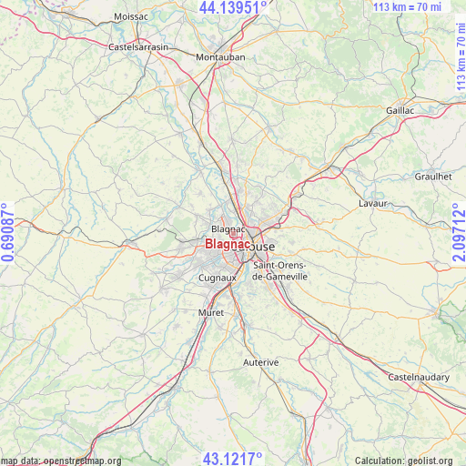
Blagnac GPS coordinates[2]
43° 37' 57.936" North, 1° 23' 38.364" East
| Map corner | latitude | longitude |
|---|---|---|
| Upper-left | 44.13951°, | 0.69087° |
| Center: | 43.63276°, | 1.39399° |
| Lower-right: | 43.1217°, | 2.09712° |
| Map W x H: | 113.2×113.2 km | = 70.3×70.3mi |
| max Lat: | 51.07786° ⇑91.5% North |
| Blagnac: | 43.63276° |
| min Lat: | ⇓8.5% South 41.3874° |
| min Long | Blagnac | max Long |
| -5.08615° | 1.39399° | 9.52242° |
| W 35.6%⇐ | ⇒64.4% E |
Elevation
Elevation of Blagnac is 139 m = 456 ft, and this is 54.7 m = 179 ft below average elevation for this country.
| Max E: |
2333 m = 7654 ft | 48.1% |
| Avg. | 193.7 m = 635 ft | |
| Blagnac | 139 m = 456 ft | |
Min E: |
-1 m = -3 ft | 51.9% |
See also: France elevation on elevation.city.
Geographical zone
Blagnac is located in North temperate zone (between Tropic of Cancer and the Arctic Circle). Distance of this Northern Tropic circle is 2245.6 km =1395.4 mi to South.| Distance of | km | miles | from Blagnac |
|---|---|---|---|
| North Pole | 5155.6 | 3203.5 | to North |
| Arctic Circle | 2549.7 | 1584.3 | to North |
| Tropic Cancer | 2245.6 | 1395.4 | to South |
| Equator | 4851.5 | 3014.6 | to South |


Nearby cities:
15 places around Blagnac: (largest is in red/bold)
• Aucamville
5 km =3.1 mi,  33°
33°
• Aussonne
8.1 km =5 mi,  311°
311°
• Beauzelle
4.1 km =2.5 mi,  338°
338°
• Castelginest
7.5 km =4.7 mi, 25°
• Colomiers
5.4 km =3.4 mi,  242°
242°
• Cornebarrieu
5.9 km =3.7 mi,  287°
287°
• Fenouillet
5.3 km =3.3 mi,  358°
358°
• Fonbeauzard
6 km =3.7 mi, 32°
• Gagnac-sur-Garonne
7.6 km =4.7 mi,  348°
348°
• L'Union
7.8 km =4.8 mi,  66°
66°
• Launaguet
7.1 km =4.4 mi,  44°
44°
• Saint-Alban
6.8 km =4.2 mi,  11°
11°
• Seilh
7.6 km =4.7 mi, 335°
• Toulouse
5.1 km =3.2 mi,  128°
128°
• Tournefeuille
7.8 km =4.8 mi,  230°
230°
Sources, notices
• [Note1] Compared only with cities in France existing in our database
• [Src1] Map data: © OpenStreetMap contributors (CC-BY-SA)
• [Src2] Other city data from geonames.org with taken over terms of usage.
• [Src3] Geographical zone / Annual Mean Temperature by Robert A. Rohde @ Wikipedia
