Colomiers geodata
Colomiers (Occitanie) is a populated place; located in France in Europe/Paris (GMT+2) time zone. With population of 31,363 people, there are 253 cities with bigger population in this country. Compared to other cities in France, 91.7% of cities are located further ↑North; 65.2% of cities are located further →East and 63.3% of cities have lower elevation than Colomiers. Note1
Administrative division(s):
- Level 1: Occitanie
- Level 2: Haute-Garonne
- Level 3: Arrondissement de Toulouse
- Level 4: Colomiers


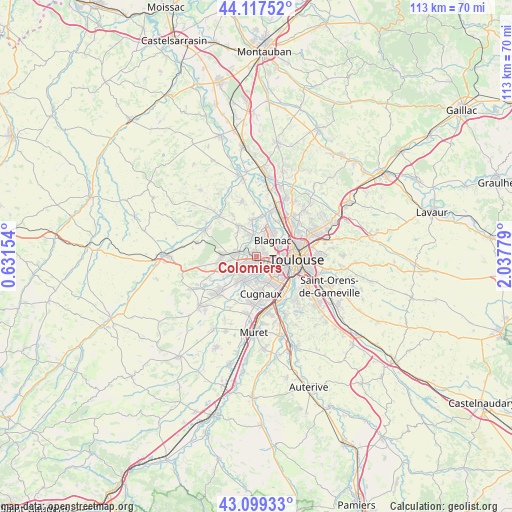
Colomiers GPS coordinates[2]
43° 36' 38.088" North, 1° 20' 4.812" East
| Map corner | latitude | longitude |
|---|---|---|
| Upper-left | 44.11752°, | 0.63154° |
| Center: | 43.61058°, | 1.33467° |
| Lower-right: | 43.09933°, | 2.03779° |
| Map W x H: | 113.2×113.2 km | = 70.3×70.3mi |
| max Lat: | 51.07786° ⇑91.7% North |
| Colomiers: | 43.61058° |
| min Lat: | ⇓8.3% South 41.3874° |
| min Long | Colomiers | max Long |
| -5.08615° | 1.33467° | 9.52242° |
| W 34.8%⇐ | ⇒65.2% E |
Elevation
Elevation of Colomiers is 186 m = 610 ft, and this is 7.7 m = 25 ft below average elevation for this country.
| Max E: |
2333 m = 7654 ft | 36.7% |
| Avg. | 193.7 m = 635 ft | |
| Colomiers | 186 m = 610 ft | |
Min E: |
-1 m = -3 ft | 63.3% |
See also: France elevation on elevation.city.
Geographical zone
Colomiers is located in North temperate zone (between Tropic of Cancer and the Arctic Circle). Distance of this Northern Tropic circle is 2243.1 km =1393.8 mi to South.| Distance of | km | miles | from Colomiers |
|---|---|---|---|
| North Pole | 5158 | 3205 | to North |
| Arctic Circle | 2552.1 | 1585.8 | to North |
| Tropic Cancer | 2243.1 | 1393.8 | to South |
| Equator | 4849 | 3013 | to South |


Nearby cities:
15 places around Colomiers: (largest is in red/bold)
• Aussonne
8 km =5 mi,  350°
350°
• Beauzelle
7.1 km =4.4 mi,  27°
27°
• Blagnac
5.4 km =3.4 mi,  62°
62°
• Brax
7.7 km =4.8 mi,  276°
276°
• Cornebarrieu
4.4 km =2.7 mi, 348°
• Cugnaux
8.3 km =5.2 mi,  174°
174°
• Fenouillet
9 km =5.6 mi, 30°
• La Salvetat-Saint-Gilles
6.3 km =3.9 mi,  232°
232°
• Léguevin
8.3 km =5.2 mi,  262°
262°
• Mondonville
8 km =5 mi,  330°
330°
• Pibrac
4.1 km =2.5 mi,  285°
285°
• Plaisance-du-Touch
5.8 km =3.6 mi,  210°
210°
• Seilh
9.5 km =5.9 mi,  9°
9°
• Toulouse
8.8 km =5.5 mi,  94°
94°
• Tournefeuille
2.7 km =1.7 mi, 207°
Sources, notices
• [Note1] Compared only with cities in France existing in our database
• [Src1] Map data: © OpenStreetMap contributors (CC-BY-SA)
• [Src2] Other city data from geonames.org with taken over terms of usage.
• [Src3] Geographical zone / Annual Mean Temperature by Robert A. Rohde @ Wikipedia
