Toulon-sur-Arroux geodata
Toulon-sur-Arroux (Bourgogne-Franche-Comté) is a populated place; located in France in Europe/Paris (GMT+2) time zone. With population of 1,655 people, there are 5649 cities with bigger population in this country. Compared to other cities in France, 58.3% of cities are located further ↑North; 69.2% of cities are located further ←West and 77.1% of cities have lower elevation than Toulon-sur-Arroux. Note1
Administrative division(s):
- Level 1: Bourgogne-Franche-Comté
- Level 2: Département de Saône-et-Loire
- Level 3: Arrondissement de Charolles
- Level 4: Toulon-sur-Arroux


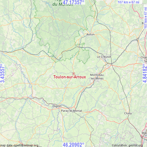
Toulon-sur-Arroux GPS coordinates[2]
46° 41' 36.42" North, 4° 8' 19.284" East
| Map corner | latitude | longitude |
|---|---|---|
| Upper-left | 47.17357°, | 3.43557° |
| Center: | 46.69345°, | 4.13869° |
| Lower-right: | 46.20902°, | 4.84182° |
| Map W x H: | 107.2×107.2 km | = 66.6×66.6mi |
| max Lat: | 51.07786° ⇑58.3% North |
| Toulon-sur-Arroux: | 46.69345° |
| min Lat: | ⇓41.7% South 41.3874° |
| min Long | Toulon-sur-Arro | max Long |
| -5.08615° | 4.13869° | 9.52242° |
| W 69.2%⇐ | ⇒30.8% E |
Elevation
Elevation of Toulon-sur-Arroux is 264 m = 866 ft, and this is 70.3 m = 231 ft above average elevation for this country.
| Max E: |
2333 m = 7654 ft | 22.9% |
| Toulon-sur-Arroux | 264 m 866 ft | |
| Avg. | 193.7 m = 635 ft | |
Min E: |
-1 m = -3 ft | 77.1% |
See also: France elevation on elevation.city.
Geographical zone
Toulon-sur-Arroux is located in North temperate zone (between Tropic of Cancer and the Arctic Circle). Distance of this North polar circle is 2209.3 km =1372.8 mi to North.| Distance of | km | miles | from Toulon-sur-Arroux |
|---|---|---|---|
| North Pole | 4815.2 | 2992 | to North |
| Arctic Circle | 2209.3 | 1372.8 | to North |
| Tropic Cancer | 2585.9 | 1606.8 | to South |
| Equator | 5191.8 | 3226 | to South |


Nearby cities:
15 places around Toulon-sur-Arroux: (largest is in red/bold)
• Ciry-le-Noble
15.6 km =9.7 mi,  128°
128°
• Grury
17.5 km =10.9 mi,  263°
263°
• Gueugnon
11.5 km =7.1 mi,  210°
210°
• Génelard
14.5 km =9 mi,  149°
149°
• Issy-l’Évêque
12.7 km =7.9 mi,  277°
277°
• Luzy
16.7 km =10.4 mi,  309°
309°
• Montceau-les-Mines
17.6 km =10.9 mi,  99°
99°
• Palinges
16.7 km =10.4 mi,  158°
158°
• Perrecy-les-Forges
10.5 km =6.5 mi, 146°
• Saint-Berain-sous-Sanvignes
11.9 km =7.4 mi,  82°
82°
• Saint-Vallier
18.7 km =11.6 mi,  108°
108°
• Sanvignes-les-Mines
12.1 km =7.5 mi, 105°
• Uxeau
9.4 km =5.8 mi,  248°
248°
• Vendenesse-sur-Arroux
9.2 km =5.7 mi,  217°
217°
• Vitry-en-Charollais
12.1 km =7.5 mi,  325°
325°
Sources, notices
• [Note1] Compared only with cities in France existing in our database
• [Src1] Map data: © OpenStreetMap contributors (CC-BY-SA)
• [Src2] Other city data from geonames.org with taken over terms of usage.
• [Src3] Geographical zone / Annual Mean Temperature by Robert A. Rohde @ Wikipedia
