Vitry-en-Charollais geodata
Vitry-en-Charollais (Bourgogne-Franche-Comté) is a populated place; located in France in Europe/Paris (GMT+2) time zone. With population of 983 people, there are 8958 cities with bigger population in this country. Compared to other cities in France, 57.4% of cities are located further ↑North; 68.3% of cities are located further ←West and 88.2% of cities have lower elevation than Vitry-en-Charollais. Note1
Administrative division(s):
- Level 1: Bourgogne-Franche-Comté
- Level 2: Département de Saône-et-Loire
- Level 3: Arrondissement de Charolles
- Level 4: Vitry-en-Charollais


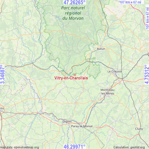
Vitry-en-Charollais GPS coordinates[2]
46° 46' 59.988" North, 4° 3' 0" East
| Map corner | latitude | longitude |
|---|---|---|
| Upper-left | 47.26265°, | 3.34687° |
| Center: | 46.78333°, | 4.05° |
| Lower-right: | 46.29971°, | 4.75312° |
| Map W x H: | 107.1×107.1 km | = 66.5×66.5mi |
| max Lat: | 51.07786° ⇑57.4% North |
| Vitry-en-Charollais: | 46.78333° |
| min Lat: | ⇓42.6% South 41.3874° |
| min Long | Vitry-en-Charol | max Long |
| -5.08615° | 4.05° | 9.52242° |
| W 68.3%⇐ | ⇒31.7% E |
Elevation
Elevation of Vitry-en-Charollais is 392 m = 1286 ft, and this is 198.3 m = 651 ft above average elevation for this country.
| Max E: |
2333 m = 7654 ft | 11.8% |
| Vitry-en-Charollais | 392 m 1286 ft | |
| Avg. | 193.7 m = 635 ft | |
Min E: |
-1 m = -3 ft | 88.2% |
See also: France elevation on elevation.city.
Geographical zone
Vitry-en-Charollais is located in North temperate zone (between Tropic of Cancer and the Arctic Circle). Distance of this North polar circle is 2199.4 km =1366.6 mi to North.| Distance of | km | miles | from Vitry-en-Charollais |
|---|---|---|---|
| North Pole | 4805.2 | 2985.8 | to North |
| Arctic Circle | 2199.4 | 1366.6 | to North |
| Tropic Cancer | 2595.9 | 1613 | to South |
| Equator | 5201.8 | 3232.2 | to South |


Nearby cities:
15 places around Vitry-en-Charollais: (largest is in red/bold)
• Broye
20.8 km =12.9 mi,  61°
61°
• Grury
16 km =9.9 mi,  221°
221°
• Gueugnon
20 km =12.4 mi,  177°
177°
• Issy-l’Évêque
10.2 km =6.3 mi,  214°
214°
• Laizy
17.9 km =11.1 mi,  39°
39°
• Luzy
6.1 km =3.8 mi,  277°
277°
• Mesvres
17.1 km =10.6 mi, 58°
• Saint-Berain-sous-Sanvignes
20.5 km =12.7 mi,  114°
114°
• Saint-Honoré-les-Bains
21 km =13 mi,  308°
308°
• Saint-Léger-sous-Beuvray
16 km =9.9 mi,  14°
14°
• Toulon-sur-Arroux
12.1 km =7.5 mi,  145°
145°
• Uxeau
13.5 km =8.4 mi,  188°
188°
• Vendenesse-sur-Arroux
17.3 km =10.7 mi, 176°
• Villapourçon
19.7 km =12.2 mi,  339°
339°
• Étang-sur-Arroux
14 km =8.7 mi,  49°
49°
Sources, notices
• [Note1] Compared only with cities in France existing in our database
• [Src1] Map data: © OpenStreetMap contributors (CC-BY-SA)
• [Src2] Other city data from geonames.org with taken over terms of usage.
• [Src3] Geographical zone / Annual Mean Temperature by Robert A. Rohde @ Wikipedia
