Tosse geodata
Tosse (Nouvelle-Aquitaine) is a populated place; located in France in Europe/Paris (GMT+2) time zone. With population of 1,820 people, there are 5213 cities with bigger population in this country. Compared to other cities in France, 90.6% of cities are located further ↑North; 91% of cities are located further →East and 91.6% of cities have higher elevation than Tosse. Note1
Administrative division(s):
- Level 1: Nouvelle-Aquitaine
- Level 2: Landes
- Level 3: Arrondissement de Dax
- Level 4: Tosse


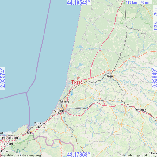
Tosse GPS coordinates[2]
43° 41' 20.976" North, 1° 19' 57.432" West
| Map corner | latitude | longitude |
|---|---|---|
| Upper-left | 44.19543°, | -2.03574° |
| Center: | 43.68916°, | -1.33262° |
| Lower-right: | 43.17858°, | -0.62949° |
| Map W x H: | 113.1×113.1 km | = 70.3×70.3mi |
| max Lat: | 51.07786° ⇑90.6% North |
| Tosse: | 43.68916° |
| min Lat: | ⇓9.4% South 41.3874° |
| min Long | Tosse | max Long |
| -5.08615° | -1.33262° | 9.52242° |
| W 9%⇐ | ⇒91% E |
Elevation
Elevation of Tosse is 26 m = 85 ft, and this is 167.7 m = 550 ft below average elevation for this country.
| Max E: |
2333 m = 7654 ft | 91.6% |
| Avg. | 193.7 m = 635 ft | |
| Tosse | 26 m = 85 ft | |
Min E: |
-1 m = -3 ft | 8.4% |
See also: France elevation on elevation.city.
Geographical zone
Tosse is located in North temperate zone (between Tropic of Cancer and the Arctic Circle). Distance of this Northern Tropic circle is 2251.9 km =1399.3 mi to South.| Distance of | km | miles | from Tosse |
|---|---|---|---|
| North Pole | 5149.3 | 3199.6 | to North |
| Arctic Circle | 2543.4 | 1580.4 | to North |
| Tropic Cancer | 2251.9 | 1399.3 | to South |
| Equator | 4857.8 | 3018.5 | to South |


Nearby cities:
15 places around Tosse: (largest is in red/bold)
• Angresse
4.7 km =2.9 mi,  222°
222°
• Bénesse-Maremne
6.2 km =3.9 mi,  199°
199°
• Capbreton
9.3 km =5.8 mi,  235°
235°
• Josse
10.5 km =6.5 mi,  120°
120°
• Pey
12.5 km =7.8 mi, 122°
• Saint-Geours-de-Maremne
8.3 km =5.2 mi,  89°
89°
• Saint-Jean-de-Marsacq
9.3 km =5.8 mi,  139°
139°
• Saint-Vincent-de-Tyrosse
3.8 km =2.4 mi,  148°
148°
• Saubion
2.3 km =1.4 mi,  212°
212°
• Saubrigues
8.9 km =5.5 mi,  170°
170°
• Saubusse
12.3 km =7.6 mi,  105°
105°
• Seignosse
3 km =1.9 mi,  266°
266°
• Soorts-Hossegor
5.8 km =3.6 mi, 242°
• Soustons
7.1 km =4.4 mi,  3°
3°
• Vieux-Boucau-les-Bains
12.4 km =7.7 mi,  334°
334°
Sources, notices
• [Note1] Compared only with cities in France existing in our database
• [Src1] Map data: © OpenStreetMap contributors (CC-BY-SA)
• [Src2] Other city data from geonames.org with taken over terms of usage.
• [Src3] Geographical zone / Annual Mean Temperature by Robert A. Rohde @ Wikipedia
