Soustons geodata
Soustons (Nouvelle-Aquitaine) is a populated place; located in France in Europe/Paris (GMT+2) time zone. With population of 6,738 people, there are 1475 cities with bigger population in this country. Compared to other cities in France, 89.7% of cities are located further ↑North; 91% of cities are located further →East and 96.7% of cities have higher elevation than Soustons. Note1
Administrative division(s):
- Level 1: Nouvelle-Aquitaine
- Level 2: Landes
- Level 3: Arrondissement de Dax
- Level 4: Soustons


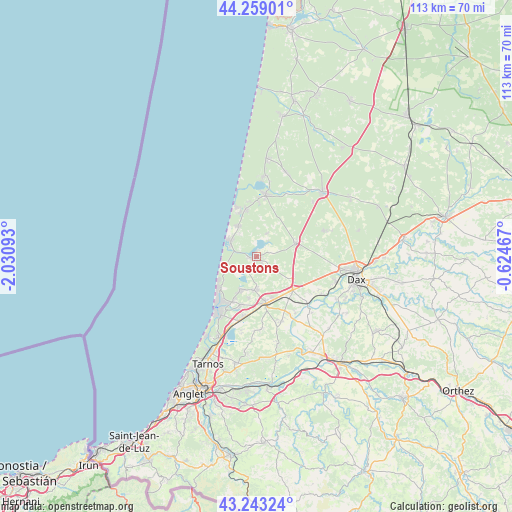
Soustons GPS coordinates[2]
43° 45' 11.808" North, 1° 19' 40.08" West
| Map corner | latitude | longitude |
|---|---|---|
| Upper-left | 44.25901°, | -2.03093° |
| Center: | 43.75328°, | -1.3278° |
| Lower-right: | 43.24324°, | -0.62467° |
| Map W x H: | 112.9×112.9 km | = 70.2×70.2mi |
| max Lat: | 51.07786° ⇑89.7% North |
| Soustons: | 43.75328° |
| min Lat: | ⇓10.3% South 41.3874° |
| min Long | Soustons | max Long |
| -5.08615° | -1.3278° | 9.52242° |
| W 9%⇐ | ⇒91% E |
Elevation
Elevation of Soustons is 12 m = 39 ft, and this is 181.7 m = 596 ft below average elevation for this country.
| Max E: |
2333 m = 7654 ft | 96.7% |
| Avg. | 193.7 m = 635 ft | |
| Soustons | 12 m = 39 ft | |
Min E: |
-1 m = -3 ft | 3.3% |
See also: France elevation on elevation.city.
Geographical zone
Soustons is located in North temperate zone (between Tropic of Cancer and the Arctic Circle). Distance of this Northern Tropic circle is 2259 km =1403.7 mi to South.| Distance of | km | miles | from Soustons |
|---|---|---|---|
| North Pole | 5142.2 | 3195.2 | to North |
| Arctic Circle | 2536.3 | 1576 | to North |
| Tropic Cancer | 2259 | 1403.7 | to South |
| Equator | 4864.9 | 3022.9 | to South |


Nearby cities:
15 places around Soustons: (largest is in red/bold)
• Angresse
11.2 km =7 mi,  198°
198°
• Bénesse-Maremne
13.2 km =8.2 mi,  190°
190°
• Capbreton
14.8 km =9.2 mi,  213°
213°
• Josse
15.1 km =9.4 mi,  144°
144°
• Léon
13.9 km =8.6 mi,  9°
9°
• Magescq
9.5 km =5.9 mi,  70°
70°
• Messanges
7.9 km =4.9 mi,  329°
329°
• Moliets-et-Maa
10.9 km =6.8 mi,  346°
346°
• Saint-Geours-de-Maremne
10.6 km =6.6 mi,  131°
131°
• Saint-Vincent-de-Tyrosse
10.5 km =6.5 mi,  171°
171°
• Saubion
9.3 km =5.8 mi, 190°
• Seignosse
8 km =5 mi, 204°
• Soorts-Hossegor
11.3 km =7 mi, 209°
• Tosse
7.1 km =4.4 mi,  183°
183°
• Vieux-Boucau-les-Bains
7 km =4.3 mi,  304°
304°
Sources, notices
• [Note1] Compared only with cities in France existing in our database
• [Src1] Map data: © OpenStreetMap contributors (CC-BY-SA)
• [Src2] Other city data from geonames.org with taken over terms of usage.
• [Src3] Geographical zone / Annual Mean Temperature by Robert A. Rohde @ Wikipedia
