Torfou geodata
Torfou (Pays de la Loire) is a populated place; located in France in Europe/Paris (GMT+2) time zone. With population of 2,023 people, there are 4733 cities with bigger population in this country. Compared to other cities in France, 54.9% of cities are located further ↑North; 89.3% of cities are located further →East and 60% of cities have higher elevation than Torfou. Note1
Administrative division(s):
- Level 1: Pays de la Loire
- Level 2: Département de Maine-et-Loire
- Level 3: Arrondissement de Cholet
- Level 4: Sèvremoine


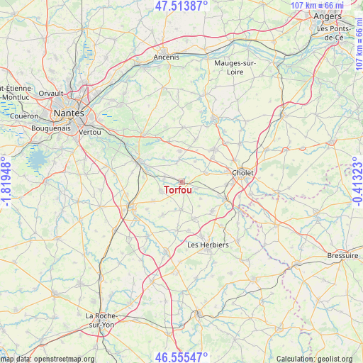
Torfou GPS coordinates[2]
47° 2' 12.552" North, 1° 6' 58.86" West
| Map corner | latitude | longitude |
|---|---|---|
| Upper-left | 47.51387°, | -1.81948° |
| Center: | 47.03682°, | -1.11635° |
| Lower-right: | 46.55547°, | -0.41323° |
| Map W x H: | 106.6×106.6 km | = 66.2×66.2mi |
| max Lat: | 51.07786° ⇑54.9% North |
| Torfou: | 47.03682° |
| min Lat: | ⇓45.1% South 41.3874° |
| min Long | Torfou | max Long |
| -5.08615° | -1.11635° | 9.52242° |
| W 10.7%⇐ | ⇒89.3% E |
Elevation
Elevation of Torfou is 102 m = 335 ft, and this is 91.7 m = 301 ft below average elevation for this country.
| Max E: |
2333 m = 7654 ft | 60% |
| Avg. | 193.7 m = 635 ft | |
| Torfou | 102 m = 335 ft | |
Min E: |
-1 m = -3 ft | 40% |
See also: France elevation on elevation.city.
Geographical zone
Torfou is located in North temperate zone (between Tropic of Cancer and the Arctic Circle). Distance of this North polar circle is 2171.2 km =1349.1 mi to North.| Distance of | km | miles | from Torfou |
|---|---|---|---|
| North Pole | 4777.1 | 2968.4 | to North |
| Arctic Circle | 2171.2 | 1349.1 | to North |
| Tropic Cancer | 2624.1 | 1630.5 | to South |
| Equator | 5230 | 3249.8 | to South |


Nearby cities:
15 places around Torfou: (largest is in red/bold)
• Boussay
5.3 km =3.3 mi,  279°
279°
• Cugand
10.7 km =6.6 mi,  285°
285°
• La Bruffière
6.6 km =4.1 mi,  248°
248°
• La Renaudière
10.2 km =6.3 mi,  25°
25°
• La Romagne
7.8 km =4.8 mi,  69°
69°
• Le Longeron
4.9 km =3 mi,  114°
114°
• Les Landes-Genusson
7.8 km =4.8 mi,  180°
180°
• Montfaucon-Montigné
7 km =4.3 mi,  359°
359°
• Roussay
7.1 km =4.4 mi, 33°
• Saint-Aubin-des-Ormeaux
7.5 km =4.7 mi,  131°
131°
• Saint-Crespin-sur-Moine
8.8 km =5.5 mi,  322°
322°
• Saint-Germain-sur-Moine
9 km =5.6 mi, 357°
• Saint-Martin-des-Tilleuls
8.7 km =5.4 mi,  144°
144°
• Tiffauges
2.9 km =1.8 mi,  170°
170°
• Treize-Septiers
10.3 km =6.4 mi,  236°
236°
Sources, notices
• [Note1] Compared only with cities in France existing in our database
• [Src1] Map data: © OpenStreetMap contributors (CC-BY-SA)
• [Src2] Other city data from geonames.org with taken over terms of usage.
• [Src3] Geographical zone / Annual Mean Temperature by Robert A. Rohde @ Wikipedia
