Roussay geodata
Roussay (Pays de la Loire) is a populated place; located in France in Europe/Paris (GMT+2) time zone. With population of 1,060 people, there are 8398 cities with bigger population in this country. Compared to other cities in France, 54.3% of cities are located further ↑North; 88.8% of cities are located further →East and 65.6% of cities have higher elevation than Roussay. Note1
Administrative division(s):
- Level 1: Pays de la Loire
- Level 2: Département de Maine-et-Loire
- Level 3: Arrondissement de Cholet
- Level 4: Sèvremoine


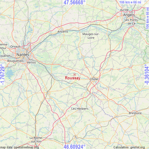
Roussay GPS coordinates[2]
47° 5' 24.396" North, 1° 3' 51.012" West
| Map corner | latitude | longitude |
|---|---|---|
| Upper-left | 47.56668°, | -1.76729° |
| Center: | 47.09011°, | -1.06417° |
| Lower-right: | 46.60924°, | -0.36104° |
| Map W x H: | 106.5×106.5 km | = 66.2×66.2mi |
| max Lat: | 51.07786° ⇑54.3% North |
| Roussay: | 47.09011° |
| min Lat: | ⇓45.7% South 41.3874° |
| min Long | Roussay | max Long |
| -5.08615° | -1.06417° | 9.52242° |
| W 11.2%⇐ | ⇒88.8% E |
Elevation
Elevation of Roussay is 88 m = 289 ft, and this is 105.7 m = 347 ft below average elevation for this country.
| Max E: |
2333 m = 7654 ft | 65.6% |
| Avg. | 193.7 m = 635 ft | |
| Roussay | 88 m = 289 ft | |
Min E: |
-1 m = -3 ft | 34.4% |
See also: France elevation on elevation.city.
Geographical zone
Roussay is located in North temperate zone (between Tropic of Cancer and the Arctic Circle). Distance of this North polar circle is 2165.2 km =1345.4 mi to North.| Distance of | km | miles | from Roussay |
|---|---|---|---|
| North Pole | 4771.1 | 2964.6 | to North |
| Arctic Circle | 2165.2 | 1345.4 | to North |
| Tropic Cancer | 2630 | 1634.2 | to South |
| Equator | 5235.9 | 3253.4 | to South |


Nearby cities:
15 places around Roussay: (largest is in red/bold)
• Boussay
10.4 km =6.5 mi,  241°
241°
• Gesté
10.7 km =6.6 mi,  341°
341°
• La Renaudière
3.4 km =2.1 mi,  7°
7°
• La Romagne
4.6 km =2.9 mi,  133°
133°
• La Séguinière
10 km =6.2 mi,  107°
107°
• Le Longeron
8 km =5 mi,  176°
176°
• Montfaucon-Montigné
4.1 km =2.5 mi,  285°
285°
• Saint-André-de-la-Marche
5.4 km =3.4 mi,  78°
78°
• Saint-Crespin-sur-Moine
9.3 km =5.8 mi,  276°
276°
• Saint-Germain-sur-Moine
5.3 km =3.3 mi,  304°
304°
• Saint-Macaire-en-Mauges
6.7 km =4.2 mi,  56°
56°
• Tiffauges
9.5 km =5.9 mi,  201°
201°
• Tillières
9.6 km =6 mi,  308°
308°
• Torfou
7.1 km =4.4 mi,  213°
213°
• Villedieu-la-Blouère
6.4 km =4 mi,  0°
0°
Sources, notices
• [Note1] Compared only with cities in France existing in our database
• [Src1] Map data: © OpenStreetMap contributors (CC-BY-SA)
• [Src2] Other city data from geonames.org with taken over terms of usage.
• [Src3] Geographical zone / Annual Mean Temperature by Robert A. Rohde @ Wikipedia
