Montfaucon-Montigné geodata
Montfaucon-Montigné (Pays de la Loire) is a populated place; located in France in Europe/Paris (GMT+2) time zone. With population of 1,756 people, there are 5395 cities with bigger population in this country. Compared to other cities in France, 54.2% of cities are located further ↑North; 89.3% of cities are located further →East and 82.6% of cities have higher elevation than Montfaucon-Montigné. Note1
Administrative division(s):
- Level 1: Pays de la Loire
- Level 2: Département de Maine-et-Loire
- Level 3: Arrondissement de Cholet
- Level 4: Sèvremoine


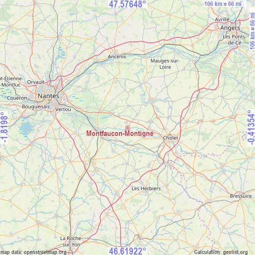
Montfaucon-Montigné GPS coordinates[2]
47° 6' 0" North, 1° 7' 0.012" West
| Map corner | latitude | longitude |
|---|---|---|
| Upper-left | 47.57648°, | -1.8198° |
| Center: | 47.1°, | -1.11667° |
| Lower-right: | 46.61922°, | -0.41354° |
| Map W x H: | 106.4×106.4 km | = 66.1×66.1mi |
| max Lat: | 51.07786° ⇑54.2% North |
| Montfaucon-Montigné: | 47.1° |
| min Lat: | ⇓45.8% South 41.3874° |
| min Long | Montfaucon-Mont | max Long |
| -5.08615° | -1.11667° | 9.52242° |
| W 10.7%⇐ | ⇒89.3% E |
Elevation
Elevation of Montfaucon-Montigné is 48 m = 157 ft, and this is 145.7 m = 478 ft below average elevation for this country.
| Max E: |
2333 m = 7654 ft | 82.6% |
| Avg. | 193.7 m = 635 ft | |
| Montfaucon-Montigné | 48 m = 157 ft | |
Min E: |
-1 m = -3 ft | 17.4% |
See also: France elevation on elevation.city.
Geographical zone
Montfaucon-Montigné is located in North temperate zone (between Tropic of Cancer and the Arctic Circle). Distance of this North polar circle is 2164.1 km =1344.7 mi to North.| Distance of | km | miles | from Montfaucon-Montigné |
|---|---|---|---|
| North Pole | 4770 | 2963.9 | to North |
| Arctic Circle | 2164.1 | 1344.7 | to North |
| Tropic Cancer | 2631.1 | 1634.9 | to South |
| Equator | 5237 | 3254.1 | to South |


Nearby cities:
15 places around Montfaucon-Montigné: (largest is in red/bold)
• Boussay
8 km =5 mi,  220°
220°
• Gesté
9.1 km =5.7 mi,  3°
3°
• La Regrippière
10.1 km =6.3 mi,  333°
333°
• La Renaudière
4.9 km =3 mi,  62°
62°
• La Romagne
8.5 km =5.3 mi,  120°
120°
• Le Longeron
10.1 km =6.3 mi,  153°
153°
• Roussay
4.1 km =2.5 mi,  105°
105°
• Saint-André-de-la-Marche
9.3 km =5.8 mi,  90°
90°
• Saint-Crespin-sur-Moine
5.3 km =3.3 mi,  269°
269°
• Saint-Germain-sur-Moine
2 km =1.2 mi,  347°
347°
• Saint-Macaire-en-Mauges
9.8 km =6.1 mi,  74°
74°
• Tiffauges
9.9 km =6.2 mi,  177°
177°
• Tillières
6 km =3.7 mi,  324°
324°
• Torfou
7 km =4.3 mi, 179°
• Villedieu-la-Blouère
6.7 km =4.2 mi,  37°
37°
Sources, notices
• [Note1] Compared only with cities in France existing in our database
• [Src1] Map data: © OpenStreetMap contributors (CC-BY-SA)
• [Src2] Other city data from geonames.org with taken over terms of usage.
• [Src3] Geographical zone / Annual Mean Temperature by Robert A. Rohde @ Wikipedia
