Thusy geodata
Thusy (Auvergne-Rhône-Alpes) is a populated place; located in France in Europe/Paris (GMT+2) time zone. With population of 859 people, there are 9999 cities with bigger population in this country. Compared to other cities in France, 66.9% of cities are located further ↑North; 86.6% of cities are located further ←West and 95% of cities have lower elevation than Thusy. Note1
Administrative division(s):
- Level 1: Auvergne-Rhône-Alpes
- Level 2: Haute-Savoie
- Level 3: Annecy
- Level 4: Thusy


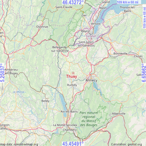
Thusy GPS coordinates[2]
45° 56' 45.492" North, 5° 57' 12.6" East
| Map corner | latitude | longitude |
|---|---|---|
| Upper-left | 46.43272°, | 5.25037° |
| Center: | 45.94597°, | 5.9535° |
| Lower-right: | 45.45491°, | 6.65662° |
| Map W x H: | 108.7×108.7 km | = 67.5×67.5mi |
| max Lat: | 51.07786° ⇑66.9% North |
| Thusy: | 45.94597° |
| min Lat: | ⇓33.1% South 41.3874° |
| min Long | Thusy | max Long |
| -5.08615° | 5.9535° | 9.52242° |
| W 86.6%⇐ | ⇒13.4% E |
Elevation
Elevation of Thusy is 587 m = 1926 ft, and this is 393.3 m = 1290 ft above average elevation for this country.
| Max E: |
2333 m = 7654 ft | 5% |
| Thusy | 587 m 1926 ft | |
| Avg. | 193.7 m = 635 ft | |
Min E: |
-1 m = -3 ft | 95% |
See also: France elevation on elevation.city.
Geographical zone
Thusy is located in North temperate zone (between Tropic of Cancer and the Arctic Circle). Distance of this North polar circle is 2292.5 km =1424.5 mi to North.| Distance of | km | miles | from Thusy |
|---|---|---|---|
| North Pole | 4898.3 | 3043.7 | to North |
| Arctic Circle | 2292.5 | 1424.5 | to North |
| Tropic Cancer | 2502.8 | 1555.2 | to South |
| Equator | 5108.7 | 3174.4 | to South |


Nearby cities:
15 places around Thusy: (largest is in red/bold)
• Chilly
5.1 km =3.2 mi,  1°
1°
• Desingy
7.5 km =4.7 mi,  317°
317°
• Hauteville-sur-Fier
4.9 km =3 mi,  162°
162°
• La Balme-de-Sillingy
7.3 km =4.5 mi,  69°
69°
• Lovagny
7.7 km =4.8 mi,  127°
127°
• Menthonnex-sous-Clermont
2.5 km =1.6 mi, 323°
• Mésigny
6.3 km =3.9 mi,  38°
38°
• Nonglard
6 km =3.7 mi,  118°
118°
• Sales
8 km =5 mi,  176°
176°
• Sallenôves
7.4 km =4.6 mi,  27°
27°
• Sillingy
7 km =4.3 mi,  88°
88°
• Vallières
5.2 km =3.2 mi,  192°
192°
• Vaulx
3.7 km =2.3 mi, 119°
• Versonnex
2.8 km =1.7 mi,  228°
228°
• Étercy
7.2 km =4.5 mi,  145°
145°
Sources, notices
• [Note1] Compared only with cities in France existing in our database
• [Src1] Map data: © OpenStreetMap contributors (CC-BY-SA)
• [Src2] Other city data from geonames.org with taken over terms of usage.
• [Src3] Geographical zone / Annual Mean Temperature by Robert A. Rohde @ Wikipedia
