La Balme-de-Sillingy geodata
La Balme-de-Sillingy (Auvergne-Rhône-Alpes) is a populated place; located in France in Europe/Paris (GMT+2) time zone. With population of 4,205 people, there are 2338 cities with bigger population in this country. Compared to other cities in France, 66.6% of cities are located further ↑North; 87.5% of cities are located further ←West and 94.4% of cities have lower elevation than La Balme-de-Sillingy. Note1
Administrative division(s):
- Level 1: Auvergne-Rhône-Alpes
- Level 2: Haute-Savoie
- Level 3: Annecy
- Level 4: La Balme-de-Sillingy
Current local time in La Balme-de-Sillingy:
03:04 AM, WednesdayDifference from your time zone: hours


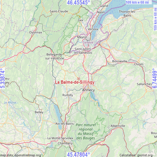
La Balme-de-Sillingy GPS coordinates[2]
45° 58' 8.04" North, 6° 2' 30.732" East
| Map corner | latitude | longitude |
|---|---|---|
| Upper-left | 46.45545°, | 5.33874° |
| Center: | 45.9689°, | 6.04187° |
| Lower-right: | 45.47804°, | 6.74499° |
| Map W x H: | 108.7×108.7 km | = 67.5×67.5mi |
| max Lat: | 51.07786° ⇑66.6% North |
| La Balme-de-Sillingy: | 45.9689° |
| min Lat: | ⇓33.4% South 41.3874° |
| min Long | La Balme-de-Sil | max Long |
| -5.08615° | 6.04187° | 9.52242° |
| W 87.5%⇐ | ⇒12.5% E |
Elevation
Elevation of La Balme-de-Sillingy is 558 m = 1831 ft, and this is 364.3 m = 1195 ft above average elevation for this country.
| Max E: |
2333 m = 7654 ft | 5.6% |
| La Balme-de-Sillingy | 558 m 1831 ft | |
| Avg. | 193.7 m = 635 ft | |
Min E: |
-1 m = -3 ft | 94.4% |
See also: France elevation on elevation.city.
Geographical zone
La Balme-de-Sillingy is located in North temperate zone (between Tropic of Cancer and the Arctic Circle). Distance of this North polar circle is 2289.9 km =1422.9 mi to North.| Distance of | km | miles | from La Balme-de-Sillingy |
|---|---|---|---|
| North Pole | 4895.8 | 3042.1 | to North |
| Arctic Circle | 2289.9 | 1422.9 | to North |
| Tropic Cancer | 2505.3 | 1556.7 | to South |
| Equator | 5111.3 | 3176 | to South |


Nearby cities:
15 places around La Balme-de-Sillingy: (largest is in red/bold)
• Allonzier-la-Caille
6.9 km =4.3 mi,  58°
58°
• Cercier
6.3 km =3.9 mi,  4°
4°
• Chilly
7.2 km =4.5 mi,  290°
290°
• Choisy
3 km =1.9 mi,  25°
25°
• Cuvat
6 km =3.7 mi,  82°
82°
• Metz
6.6 km =4.1 mi,  126°
126°
• Meythet
6.9 km =4.3 mi,  144°
144°
• Mésigny
3.7 km =2.3 mi,  308°
308°
• Nonglard
5.7 km =3.5 mi,  195°
195°
• Poisy
5.5 km =3.4 mi,  162°
162°
• Pringy
7 km =4.3 mi,  111°
111°
• Sallenôves
5.3 km =3.3 mi,  319°
319°
• Sillingy
2.4 km =1.5 mi,  175°
175°
• Vaulx
5.6 km =3.5 mi,  219°
219°
• Épagny
4.9 km =3 mi, 139°
Sources, notices
• [Note1] Compared only with cities in France existing in our database
• [Src1] Map data: © OpenStreetMap contributors (CC-BY-SA)
• [Src2] Other city data from geonames.org with taken over terms of usage.
• [Src3] Geographical zone / Annual Mean Temperature by Robert A. Rohde @ Wikipedia
