Sallenôves geodata
Sallenôves (Auvergne-Rhône-Alpes) is a populated place; located in France in Europe/Paris (GMT+2) time zone. With population of 531 people, there are 14589 cities with bigger population in this country. Compared to other cities in France, 66.1% of cities are located further ↑North; 87% of cities are located further ←West and 90.2% of cities have lower elevation than Sallenôves. Note1
Administrative division(s):
- Level 1: Auvergne-Rhône-Alpes
- Level 2: Haute-Savoie
- Level 3: Annecy
- Level 4: Sallenôves


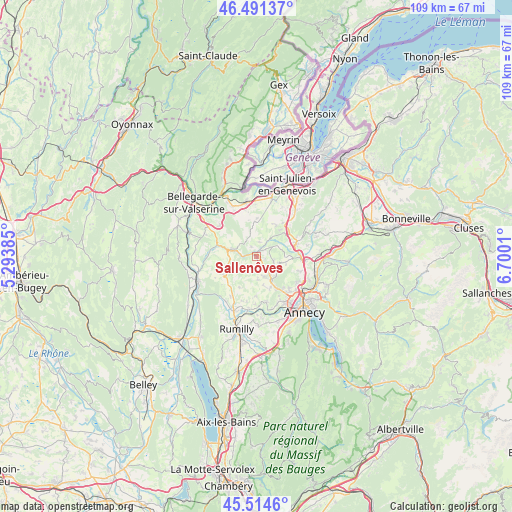
Sallenôves GPS coordinates[2]
46° 0' 18.504" North, 5° 59' 49.092" East
| Map corner | latitude | longitude |
|---|---|---|
| Upper-left | 46.49137°, | 5.29385° |
| Center: | 46.00514°, | 5.99697° |
| Lower-right: | 45.5146°, | 6.7001° |
| Map W x H: | 108.6×108.6 km | = 67.5×67.5mi |
| max Lat: | 51.07786° ⇑66.1% North |
| Sallenôves: | 46.00514° |
| min Lat: | ⇓33.9% South 41.3874° |
| min Long | Sallenôves | max Long |
| -5.08615° | 5.99697° | 9.52242° |
| W 87%⇐ | ⇒13% E |
Elevation
Elevation of Sallenôves is 430 m = 1411 ft, and this is 236.3 m = 775 ft above average elevation for this country.
| Max E: |
2333 m = 7654 ft | 9.8% |
| Sallenôves | 430 m 1411 ft | |
| Avg. | 193.7 m = 635 ft | |
Min E: |
-1 m = -3 ft | 90.2% |
See also: France elevation on elevation.city.
Geographical zone
Sallenôves is located in North temperate zone (between Tropic of Cancer and the Arctic Circle). Distance of this North polar circle is 2285.9 km =1420.4 mi to North.| Distance of | km | miles | from Sallenôves |
|---|---|---|---|
| North Pole | 4891.8 | 3039.6 | to North |
| Arctic Circle | 2285.9 | 1420.4 | to North |
| Tropic Cancer | 2509.4 | 1559.3 | to South |
| Equator | 5115.3 | 3178.5 | to South |


Nearby cities:
15 places around Sallenôves: (largest is in red/bold)
• Andilly
7.9 km =4.9 mi,  41°
41°
• Cercier
4.6 km =2.9 mi,  60°
60°
• Cernex
7.6 km =4.7 mi,  32°
32°
• Chilly
3.6 km =2.2 mi,  245°
245°
• Choisy
4.9 km =3 mi,  105°
105°
• Copponex
7.7 km =4.8 mi,  49°
49°
• Frangy
5.3 km =3.3 mi,  288°
288°
• Jonzier
7.4 km =4.6 mi,  356°
356°
• La Balme-de-Sillingy
5.3 km =3.3 mi,  139°
139°
• Menthonnex-sous-Clermont
6.7 km =4.2 mi,  226°
226°
• Minzier
5.1 km =3.2 mi,  352°
352°
• Mésigny
1.8 km =1.1 mi,  161°
161°
• Savigny
7.7 km =4.8 mi,  333°
333°
• Sillingy
7.3 km =4.5 mi,  150°
150°
• Thusy
7.4 km =4.6 mi,  207°
207°
Sources, notices
• [Note1] Compared only with cities in France existing in our database
• [Src1] Map data: © OpenStreetMap contributors (CC-BY-SA)
• [Src2] Other city data from geonames.org with taken over terms of usage.
• [Src3] Geographical zone / Annual Mean Temperature by Robert A. Rohde @ Wikipedia
