Thouarcé geodata
Thouarcé (Pays de la Loire) is a populated place; located in France in Europe/Paris (GMT+2) time zone. With population of 1,780 people, there are 5331 cities with bigger population in this country. Compared to other cities in France, 52% of cities are located further ↑North; 83.4% of cities are located further →East and 88.3% of cities have higher elevation than Thouarcé. Note1
Administrative division(s):
- Level 1: Pays de la Loire
- Level 2: Département de Maine-et-Loire
- Level 3: Angers
- Level 4: Bellevigne-en-Layon


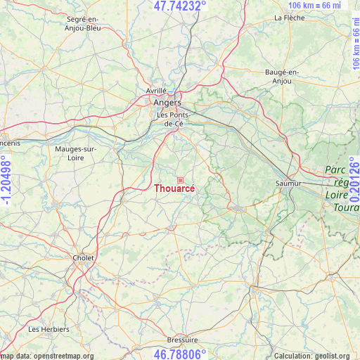
Thouarcé GPS coordinates[2]
47° 16' 2.424" North, 0° 30' 6.696" West
| Map corner | latitude | longitude |
|---|---|---|
| Upper-left | 47.74232°, | -1.20498° |
| Center: | 47.26734°, | -0.50186° |
| Lower-right: | 46.78806°, | 0.20126° |
| Map W x H: | 106.1×106.1 km | = 65.9×65.9mi |
| max Lat: | 51.07786° ⇑52% North |
| Thouarcé: | 47.26734° |
| min Lat: | ⇓48% South 41.3874° |
| min Long | Thouarcé | max Long |
| -5.08615° | -0.50186° | 9.52242° |
| W 16.6%⇐ | ⇒83.4% E |
Elevation
Elevation of Thouarcé is 34 m = 112 ft, and this is 159.7 m = 524 ft below average elevation for this country.
| Max E: |
2333 m = 7654 ft | 88.3% |
| Avg. | 193.7 m = 635 ft | |
| Thouarcé | 34 m = 112 ft | |
Min E: |
-1 m = -3 ft | 11.7% |
See also: France elevation on elevation.city.
Geographical zone
Thouarcé is located in North temperate zone (between Tropic of Cancer and the Arctic Circle). Distance of this North polar circle is 2145.5 km =1333.2 mi to North.| Distance of | km | miles | from Thouarcé |
|---|---|---|---|
| North Pole | 4751.4 | 2952.4 | to North |
| Arctic Circle | 2145.5 | 1333.2 | to North |
| Tropic Cancer | 2649.7 | 1646.4 | to South |
| Equator | 5255.6 | 3265.7 | to South |


Nearby cities:
15 places around Thouarcé: (largest is in red/bold)
• Beaulieu-sur-Layon
8.2 km =5.1 mi,  306°
306°
• Brissac-Quincé
10.6 km =6.6 mi,  21°
21°
• Chanzeaux
10.7 km =6.6 mi,  267°
267°
• Chavagnes
3.6 km =2.2 mi,  85°
85°
• Faveraye-Mâchelles
1.9 km =1.2 mi,  175°
175°
• Les Alleuds
9.1 km =5.7 mi,  51°
51°
• Martigné-Briand
6.6 km =4.1 mi,  124°
124°
• Mozé-sur-Louet
10.8 km =6.7 mi,  339°
339°
• Rablay-sur-Layon
6.4 km =4 mi,  298°
298°
• Saint-Jean
9.2 km =5.7 mi,  105°
105°
• Saint-Lambert-du-Lattay
10.7 km =6.6 mi,  291°
291°
• Saint-Melaine-sur-Aubance
11 km =6.8 mi,  0°
0°
• Soulaines-sur-Aubance
10.8 km =6.7 mi,  351°
351°
• Tigné
9.3 km =5.8 mi,  143°
143°
• Vauchrétien
7.5 km =4.7 mi,  14°
14°
Sources, notices
• [Note1] Compared only with cities in France existing in our database
• [Src1] Map data: © OpenStreetMap contributors (CC-BY-SA)
• [Src2] Other city data from geonames.org with taken over terms of usage.
• [Src3] Geographical zone / Annual Mean Temperature by Robert A. Rohde @ Wikipedia
